Following is from DOC (Department of Conservation) website to tell you everything you need to know (?) about the Tongariro Alpine Crossing.
But it’s what it doesn’t tell you that is of most concern… SWMBO (She Who Must Be Obeyed is Manager at TRM) is trying to avoid receiving more complaints from tourists.
Two issues you need to be very aware of are parking issues and crowding problems.
These important issues were in Tongariro River Motel’s Daily Report for 6 September and are repeated after the DOC info:
Description
You can walk the track in either direction, although there is less climbing if you walk from Mangatepopo (1120 m) to Ketetahi (760 m). Shuttle buses operate for walking in this direction, with services to Mangatepopo in the morning and back from Ketetahi in the afternoon. Allow an extra hour to walk the track in reverse from Ketetahi to Mangatepopo.

Tongariro Alpine Crossing profile
Walking time depends on your pace, the weather conditions, and how often you stop for breaks and sightseeing. (It also depends more on the queue in front of you!…See images below.) Times given for each track section are approximate. Allow longer in winter conditions.

The Mangatepopo Valley
Mangatepopo Valley to Soda Springs
Time: 1 – 1 hr 30 min
Beginning at the Mangatepopo Road parking area (7 kilometres off of SH47), the track makes its way up the Mangatepopo Valley. The Mangatepopo hut and campsite is along a short side track 20 minutes from the parking area. Continuing at a gentle gradient the main track climbs alongside a stream and around the edges of old lava flows.
It is generally believed that the Mangatepopo Valley was glacially carved out during the last ice age and subsequently partially in-filled by lava flows from Ngauruhoe.
Water in Mangatepopo Stream is not suitable for drinking – it contains significant levels of dissolved minerals from the volcanic rock the water passes through on the way to the surface.
Note the different colours on the lava flows as you walk up the valley. The surface colour of younger lava is darker and absorbs much of the sun’s heat – this is a harsh environment for plants to grow and the reason why the youngest flows only have a few plants, lichens and moss. The older flows have progressively more species and large plants, which take advantage of the slow build up of precious soil. The vegetation has also been modified by fire and farming.

Soda Springs
Side trip: Soda Springs
Time: 15 min return
Near the head of the Mangatepopo Valley a short sidetrack leads to the cold water Soda Springs, which seep to the surface in a boggy area at the head of the stream. The springs are an oasis for the moisture loving yellow buttercups (Ranunculus insignis).
The rocks at and below the springs are coloured golden by iron oxide, from the breakdown of volcanic ash in the bog. The water is slightly charged with dissolved gases and this effervescent quality inspired the name.
Near the head of the valley a short side track leads to Soda Springs. The springs are an oasis for the moisture loving yellow buttercups and white foxgloves.
Soda Springs to South Crater
Time: 1 hr
The track climbs steadily, gaining 340 m from Soda Springs to South Crater. You cross over two lava flows from eruptions in 1870 and two pyroclastic flows from 1975. On a clear day there are magnificent views from this section of track, as far as Mount Taranaki on the west coast.
At the top of the climb the Tongariro Alpine Crossing continues east across South Crater. A sign indicates access to Ngauruhoe summit for keen and fit walkers!
Side trip: Mount Ngauruhoe summit (2287 m)

Ngauruhoe from South Crater
Time: 3 hr return from South Crater, 6 – 7 hr return from Mangatepopo parking area
Distance: 6 km return from South Crater, 19 km return from Mangatepopo parking area
Clear visibility and no strong wind is required to safely climb Mount Ngauruhoe. You also need good fitness – the volcano is steep, and the surface is mainly loose rock and stones (scree). The summit climb is not marked or formed.
South Crater to Red Crater
Time: 45 min – 1 hr
Follow the poled route across South Crater to a ridge leading up Red Crater. South Crater is not a real crater but a basin that may have been glacially carved, and has since filled with sediment from the surrounding ridges. An explosion pit in the southeast part of the crater formed around 14,000 years ago. The lava seen from Ngauruhoe dates back to the 1870 eruption.
As you walk up the ridge to Red Crater you can smell sulphur, evidence that Red Crater is still active. Enjoy the spectacular view to the east over the Kaimanawa Forest Park and Desert Road.
Looking into Red Crater notice the unusual formation within, known as a ‘dike’. This feature was formed as molten magma moved to the surface through a vertical channel in the crater wall. Having solidified at its outer surface, the dike was later left partially hollow when the magma drained from below. Being more resistant than the surrounding scoria, erosion by wind and rain has now left this structure exposed.
The red colour is from high temperature oxidation of iron in the rock. You can see old lava flows from Red Crater extending into Oturere Valley, South and Central Craters.
From near the top of Red Crater you can take a side trip along a poled route to the summit of Mount Tongariro.

Tongariro summit route
Side trip: Mount Tongariro summit (1967 m)
Time: 1 – 2 hr return from near the top of Red Crater
Clear visibility and no strong wind is required to safely climb Mount Tongariro. From Red Crater follow a poled route to the summit of Tongariro. The route is along an undulating rocky ridge, gaining less than 100 m in altitude.
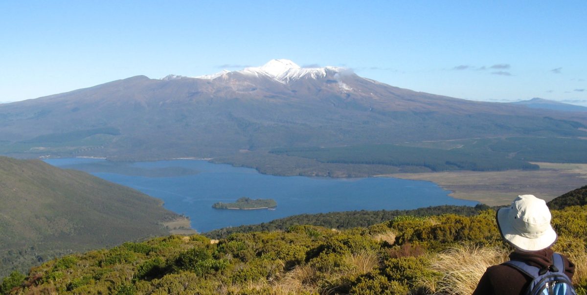
Along the way you can see interesting volcanic rock formations, and fantastic views of the mountains and landscape – including Mount Ruapehu from the Tongariro summit itself.
Red Crater to Emerald Lakes

Lower Emerald Lake and Red Crater
Time: 10 – 20 min
The summit of Red Crater (1886 m) is the highest point on the Tongariro Alpine Crossing. From here the track descends steeply to Emerald Lakes and you can see across to the Blue Lake past the Central Crater.
The Emerald Lakes’ brilliant colour is caused by minerals leaching from the adjoining thermal area. You can see thermal steaming around the Red Crater and Emerald Lakes.
The Maori name for the lakes is Ngarotopounamu meaning greenstone-hued lakes. The water is cold and acidic, and they freeze in winter.
Take care on the steep descent on loose stony terrain (scree).
The next two sections of the track go through the active volcanic zone, near Te Maari craters – the site of the 2012 volcanic eruptions. Observe the warning signs, and keep your stops to a minimum. Know about the volcanic risks and what to do in an eruption.
.")
Blue Lake(Te Wai-whakaata-o-te-Rangihiroa)
Emerald Lakes to Ketetahi shelter
Time: 1 hr – 1 hr 30 min
The Tongariro Northern Circuit Great Walk to Oturere Hut branches off to the right at the lowest lake, while the Tongariro Alpine Crossing continues over Central Crater, a drainage basic rather than a true crater.
After a short climb out of Central Crater you can see Te Wai-whakaata-o-te-Rangihiroa / Blue Lake – this translates as Rangihiroa’s mirror. Te Rangihiroa was the son of local chief Pakaurangi, and Te Maari (after whom the crater is named) was his sister. Te Rangihiroa is said to have explored the Tongariro volcanoes about AD 1750.
The Blue Lake is tapu (sacred) – do not swim in or eat food around the lake. From Blue Lake the track sidles around the flanks of North Crater (a cooled lava lake) and descends to Ketetahi shelter.

An impact crater and the Te Maari steam vents in the distance
You can see evidence from the volcanic eruptions in 2012 – excellent views of the new steaming vents at Te Maari craters, impact craters near the track, and damage to the Ketetahi hut.
To protect the fragile soil and plants it’s important that you stay on the formed track.
The Ketetahi Springs are on private land. Walking the Tongariro Alpine Crossing doesn’t give you the right to access the springs – keep to the track.
Ketetahi shelter to Ketetahi parking area
Time: 1 hr 30 min – 2 hr
The track continues to descend through golden tussock-covered slopes to the forest section. The tree line is the end of the Active Volcanic Hazard Zone. There are fantastic views of lakes Rotoaira and Taupo to the north. The cool podocarp-hardwood forest and its bird life provides a final contrast on the long descent to the roadend.
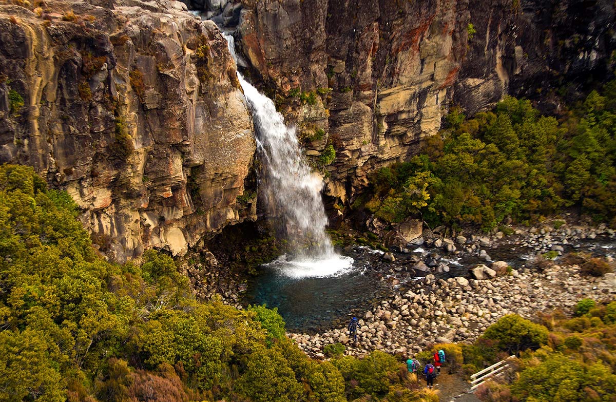
At two points the track passes over the tongue of a lava flow from Te Maari Crater and for a distance follows alongside the Manga-a-te-tipua Stream (polluted with minerals from the Ketetahi Springs). Toward the end of the track you can take a short side track to see a waterfall.
Thankyou DOC. Very good descriptions etc. BUT what it does not warn you about is…
Tongariro River Motel Daily Report for 6 September:
The tourism boom rolls on.
 For June 2016, compared with June 2015:
National guest nights were up 11.9 percent.
North Island guest nights were up 13.3 percent, and South Island guest nights were up 9.5 percent.
Domestic guest nights were up 10.9 percent, and international guest nights were up 13.7 percent.
Compare – TRM guest nights for June were up 25 percent. (but that might reflect SWMBO’s management? Or the fishing?)
All 12 regional areas had more guest nights.
All four accommodation types had more guest nights with holiday parks up a significant 26%. etc…
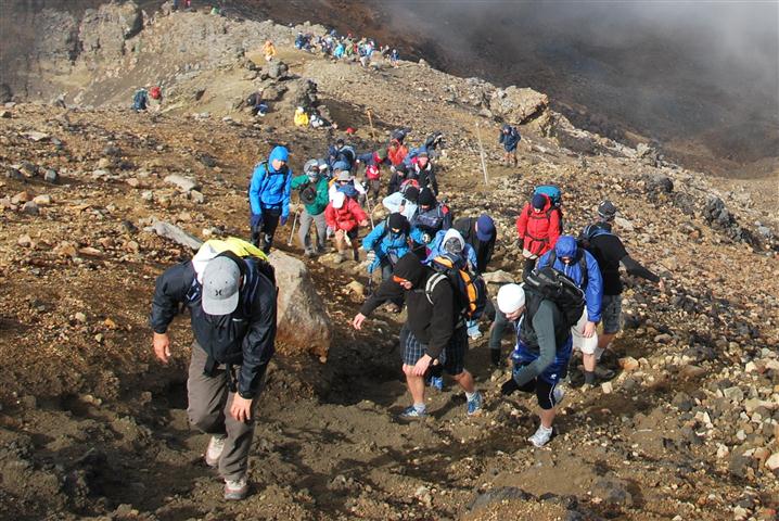
But now the sudden growth problems are emerging – such as on the Tongariro Alpine Crossing…
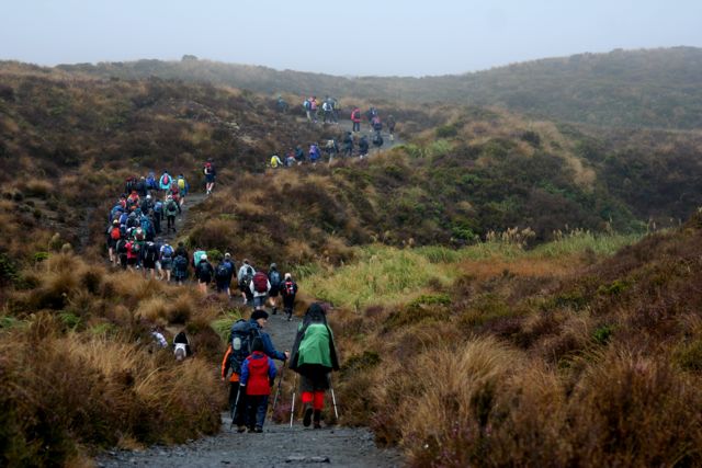
Above – Tongariro Alpine Crossing. Is this crowding and delays what tourists really expect? We have to do better than this…
 Recently TRM posted an alarming update complaining about the crowding and parking issues on the Tongariro Crossing – with two alternative options as solutions on the video – below.
Now the latest TOURISM BUSINESS magazine has featured and confirmed the problem under the sub-heading:
Tourism congestion:
How do we protect our pressure points:
 They feature the Tongariro Alpine Crossing (“TAC”) which now suffers from crowding an unacceptable crowded queues and delays and parking hassles as the number of walkers has increased fifty percent – from 80,000 to 120,000 in the past three years says DOC’s Whakapapa conservation services manager, Paul Carr.
TRM were reluctant to complain about the TAC as it is such an important tourist attraction for Turangi.
We understood the crowding has increased ever since the 1970’s when Lonely Planet editor – Tony Wheeler – first visited this area and walked the TAC .
 He wrote it up as the best one day walk in NZ . Locals wonder if he even trekked on any of the other walks around the Central Plateau? – such as the ’round the mountain tracks’ or on Mt. Ruapehu. The rest is history. It has been on everyone tourist’s bucket list ever since.
But now excessive tourist numbers have become a major problem. i.e. “At the TAC car parking is a shambles complains one guiding concession operator. “On busy days cars are parked up on the curbs and along the roadside for several km at Mangatepopo and all the way to the main road from Ketetahi, and that’s with 75% of the walkers travelling by shuttle buses from local towns. It’s a dog’s breakfast.”
 And the growth continues but the facilities have not kept pace.
The whole experience has become a ridiculously congested tourist trap. About fifty companies operate bus services to the car parks. The Mangatepopo car park was expanded in 2010, the road is graded about eight times each year. etc…
It is out of control. So you have been warned…
The TRM alternative options on our website are far better.
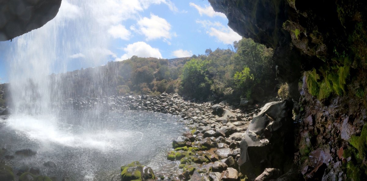 Start with the one hour circuit on the Tongariro River Trail providing wide views over Lake Taupo and Turangi; after coffee recovery travel 10km to walk for two hours around Lake Rotopounamu, beautiful original native bush around a hidden lake; then travel on to the Whakapapa Village and finish the day with the two hour circuit to Taranaki Falls – see images on right from under the waterfall…
A much better choice with five hours of walks with more variety and options not so dependent on weather conditions and away from the crowding and parking hassles.
Other more challenging options might include two hours climbing an unmarked track up Mt. Tihia. You will need TRM’s guide.
Or for a real challenge away from the queues – consider the “BIGGIE” – see video below.