Further to TRM Report on 29 May headed “GENESIS SUCKS” which suggested it was time to consider removing the Poutu Intake Dam as the existing system is too dangerous causing flash floods after heavy rain.
Any lost revenue could be replaced by the brilliant proposal to develop the new Caves of Mordor (see yesterday’s report) to replace the underground power station with a much more friendly tourist attraction. After heavy rain in the catchment the process has been to close off the canal to Lake Rotoaira to prevent pumice and other debris to float through to the turbines in the Tokaanu Power Station. Last Saturday several groups of anglers were caught unawares and were fortunate to escape without a dunking. But the risk to human safety makes this practice too dangerous to continue with. So TRM have suggested using the underground power station as a tourist attraction to compensate for any potential loss from removal of the dam.
According to Taupo Council, and they blame Waikato Regional Council, TRM (Tongariro River Motel) is now in a flood hazard zone… as is all of Turangi built on a river delta. The fact that it has never been remotely close to flooding in the last fifty years during two major one hundred year floods in 1958 & 2004 is disregarded. They have decided it is in a flood hazard zone due to global warming…
The real reason of course is the Tongariro hydro scheme with dams in the upper Tongariro River and a raised lake level resulting in a massive build up of sediment after most of the river is diverted to Lake Rotoaira to feed the turbines of the Tokaanu Power Station. The remaining flow is insufficient to carry the sediment into Lake Taupo and the raising of the bed – a process known as aggradation – is inevitable. Anglers easily understand this. Council engineers do not.
A precedent in NZ is the recent decommisioning of Huntly Power Station. More on that below. So it is interesting to find an example of what would happen if the dams were removed… Just imagine the Tongariro returning to a natural flow – what might happen to the fishery?
What Happens When Dams Come Down?
By Max Bartlett • Apr 22, 2016
 For decades, America has debated the effects of dams on rivers. But what happens when dams go away? The removal of two dams on the Elwha River – completed in 2014 – offers a rare chance to see what happens when a river is undammed.
An Oregon State University study showed that when a dam is removed from a river, its effects are gone within a year. That has largely been borne out by the removal of the Elwha and Glines Canyon dams on the Elwha River. Salmon began to return quickly, even after just the first dam came down. Fish populations are now at their highest in 30 years. As the Seattle Times reported:
“The middle Elwha and its tributaries went from no Coho at all before dam removal, to producing about 32,000 outgoing salmon fry in 2014. Chinook redd counts are up more than 350 percent and steelhead 300 percent from 2013 to 2015. Even sockeye have been spotted in Indian Creek, perhaps from landlocked kokanee in Lake Sutherland that have rediscovered their ability to go to sea.”
 “Redd,” mentioned above, are salmon spawning nests built in gravel or along the shoreline. Their numbers can be used to measure the success of salmon each year.
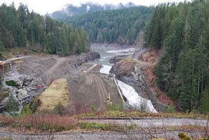
Removing the dams meant fish could freely swim the river, but it also meant the Elwha could flow where it hadn’t before – and that led to some flooding. Earlier this year, the river washed out the Elwha and Altair campgrounds as well as a section of road leading to them. The wild river has created new flood plains – or, perhaps, restored its original ones.
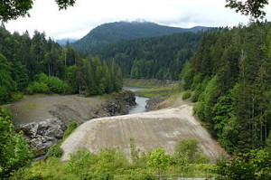
While water moved where it had not been before, one of Washington’s lakes drained and disappeared. Lake Aldwell, a reservoir created by the dam, left behind a bed of silt. Efforts are underway to plant new trees and restore the area, but they have run into budget issues. The Kitsap Sun says the recovery effort is the largest of its kind, with around 800 acres of former lake bed left exposed.
 There was also a lot of built-up sediment trapped behind the dams, which proved to be an issue for fish, and humans as well. Removal of the Glines Canyon Dam – the second of the structures to come down – was briefly put on hold in 2013 after river silt and debris began clogging up the Elwha Water Facility, which provides water to Port Angeles.
Sediment buildup can be dramatic. When the last dam was removed from the river, all that silt began to flow to the sea. Now, Washington has a new beach. The LA Times reported:
“Since removal began in 2011, Ritchie said, nearly 60% of the sediment behind the dams has made its way down the river, most of it in the fall of 2013, about a year before the last pieces of concrete were hauled away. Nearly a third of that has settled at the mouth, instantly reversing a long-standing pattern of erosion on the coastline.”
It wasn’t the first new beach to appear. The Seattle Times reported a small one emerging on the Elwha in 2012.
Despite some challenges, the Elwha continues to recover – with a little human support, such as artificially-constructed logjams to help plants and animals return to the river. But unlike the dams, these won’t block the river’s natural flow.
Copyright 2016 Northwest Public Radio
More info x Wikipedia:
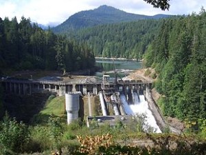
The Elwha Dam was a 108-ft (33 m) high dam located in the United States, in the state of Washington, on the Elwha River approximately 4.9 miles (7.9 km) upstream from the mouth of the river on the Strait of Juan de Fuca.
The Elwha River Ecosystem and Fisheries Restoration Act of 1992 authorized the US Federal Government to acquire the Elwha Dam and Glines Canyon Dam hydroelectric power projects for decommissioning and demolition for habitat restoration. Removal of the Elwha Dam began in September 2011 and was fully complete by March 2012, allowing the Elwha River to flow freely through the site.
Construction
The dam was built under the direction of Thomas Aldwell. Aldwell previously bought up tracts of land around the river, and with the help of Canadian financier George Glines, began construction of the Elwha Dam in 1910. Aldwell and his contractors cut corners on constructing the dam, including not building fish passages and did not secure it to the bedrock.[2] Thus, in 1912, as the reservoir filled behind the nearly completed dam, the lower sections of the dam gave way and a torrent of water headed downstream, taking out a bridge. Aldwell was able to get funding for reconstructing the dam and it was completed in 1913. The reservoir that filled the valley behind was known as Lake Aldwell. The dam was listed on the National Register of Historic Places in 1988.[3]
Initially, along with the Glines Canyon Dam, which was completed in 1926, it helped to fuel economic growth and development for the Olympic Peninsula and the community of Port Angeles, Washington. However, by the early 21st Century, the combined power output of both dams only provided the equivalent of 38% of the electricity needed to operate one paper mill, the Daishowa America mill.[citation needed]
Lacking passage for migrating salmon, its construction blocked access by anadromous salmonids to the upper 38 miles (48 km) of mainstem habitat and more than 30 miles (48 km) of tributary habitat.[citation needed] The salmon runs that once numbered more than 400,000 adult returns in over 70 miles (110 km) of available habitat, now numbered less than 4,000 adult returns on only 4.9 miles (7.9 km) of available habitat.[citation needed]
Effects of dam on river habitat

After the construction of the dams, the lower reach of the river saw a drastic decrease in sediment delivery. This led to a net erosion of the riverbed, including the gravels needed to create suitable habitats for spawning. Replacement gravel was trapped in the sediment load behind the dams.[4] These gravels are considered an essential resource for restoration of salmon habitats.[5] The delta at the mouth of the river, where it enters the Strait of Juan de Fuca, also saw a net erosion effect, confirmed by local tribal leaders.[4]
Another effect of damming was the creation of Lake Aldwell and Lake Mills. These lakes had a multitude of impacts on the river beyond sediment retention. Because the water stayed in the lake for so long, it warmed up to approximately 16 °C.[6] Normal water temperatures are around 0 °C.[7] These higher temperatures are unnatural for spawning fish, which prefer colder ocean temperature waters. This increase in temperature also increases parasite populations.[4] Disease was known to wipe out two thirds of a spawning population, before it had a chance to spawn.[4] The lakes also acted as buffers for high and low flow conditions. While the dams were not actively used for flood control, the reservoirs behind them altered the natural flow patterns of the river. The normal seasonal high and low flow were evened out by the reservoirs and dams so that flow was relatively constant throughout the year. Natural flow patterns are known to promote the health of native species and to help eliminate non native species after dam removal.[8]
History of the Elwha fishery
At its peak, the Elwha supported spawning runs of Chinook, Coho, Chum, Pink, and Sockeye Salmon as well as Steelhead, Cutthroat, and Bull Trout. The Chinook were known to reach sizes of 45 kg. Sockeye, Chinook, Chum, and Pink Salmon were all endangered in the Elwha. Leaving one or both of the dams in place, even with modern fish passage systems, would not result in a dramatic recovery of species due to other factors like water temperature, gravel beds, etc. which would still have negative effects on the fish species (see Table 1). The most valuable spawning habitats are located far upstream from the Glines Canyon Dam, so it still acted as a major barrier to the recovery of the runs. Removal of both dams was thus considered the only viable option for full restoration of the river and habitat.
Dam removal

The Elwha River Ecosystem and Fisheries Restoration Act of 1992 created funding and government support for mitigation of the dams on the Elwha. While fish ladders were proposed as a possibility, they were ultimately ruled out for the reasons above. The major problem raised with regard to removal of the two dams was the approximately 34 million cubic yards of sediment that had built up behind the dams.[10] Of that 34 million, 28 million was behind the Glines Canyon Dam, while 6 million was behind the Elwha Dam. Releasing all of this sediment at once would have devastating effects on the remaining habitats downstream from the dams, as well as along beaches at the coast. A drawdown experiment was conducted on the Glines Canyon Dam to assess the erosion of the sediments from Lake Mills.[11] The lake was drawn down 18 feet (5.5 m) over one week and then allowed to remain stable for one more week. This test showed that the river would rapidly cut into the existing delta as soon as the lake level dropped, creating a deep, narrow channel. A new delta immediately began to form at the new lake level. Once the lake level was held steady, the channel migrated laterally along the existing delta. This test resulted in a sediment erosion model in which gradual drawdown of the lake would result in a greatly decreased sediment load downstream. Using this model, the plan was to drain the lake gradually over a two-year time period, allowing much of the sediment to remain in the old lake basin.
The model showed that after the two year dam removal period, the river would begin to restore itself to natural conditions. Sediment discharge rates would increase, resulting in restored and rejuvenated habitats downstream from the dams. Fish were anticipated to return to the upper reaches of the Elwha as soon as a year after dam removal was complete.[12] While the river might never return to historically large runs, after 15–20 years or more, there should be a recovery of salmon runs to some sort of “pre-dam” condition.[4] In addition to restoring the fish habitats, the draining of Lake Mills and Lake Aldwell would create an additional 715 acres (2.9 km2) of terrestrial vegetation, improving elk habitats[8] (Figure 1). Increased sediments loads were also predicted to help restore the retreating delta at the mouth of the Elwha.
Removal of the dams on the Elwha River has been a long process. Physical removal started on September 27, 2011 and was completed August 26, 2014.[13][14] There is uncertainty about how the river will transform itself and what period of time will be involved. Because so few dam removal projects have been accompanied by scientific study, perhaps fewer than 20,[12] this project will be a model of the effectiveness of dam removal on this scale. If restoration of the river is successful, it could encourage a movement towards the restoration of natural stream morphology through the removal of larger dams. Most fish populations are expected to make a return to the river (Table 1). While fish may return to the river as soon as a year after the removal is complete,[12] it may take 15 to 20 years for the river to fully return to its pre-dam conditions.[4] The ultimate goal of the dam removal is restoring the river to a nearly pristine state.[14]
Huntly Power Station
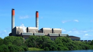 The Huntly Power Station was the largest thermal power station in New Zealand located in the town of Huntly in the Waikato. It is operated by Genesis Energy Limited, a publicly listed company, and is capable of supplying over 20% of the country’s current electricity needs.[1]
Generation
The Huntly Power Station consisted of three separate generating plants – a 500 MW coal-and-gas-fired steam plant, a 50 MW gas turbine generator, and a 403 MW combined cycle gas turbine plant.
Each of the four original generating units, which are capable of burning coal, gas, or both, installed in stages between 1973 and 1985, is capable of generating 250 MW (Megawatts) of electricity, giving a historical generating capacity of 1000 MW.[1] Its chimneys are 150 metres high[1] and each chimney has two flues that are 7 metres in diameter. The plant uses a reheat steam cycle, with C A Parsons turbines and Combustion Engineering boilers.
In 2004 the power station was upgraded with the addition of a 50 MW gas turbine plant, and in 2007 the combined cycle gas turbine (CCGT) plant was commissioned.[2] This plant increased the total generating capacity of Huntly by 403 MW (250 MW gas turbine + 135 MW steam turbine).[1] The new turbine represented an investement of NZ$520 million[3] and it increased the total installed capacity to 1453 MW.[4]
In 2007, Huntly operated at a load factor of 85% and was providing a large amount of the baseload energy needs of the northern North Island.[5] In 2007, the plant was mainly gas-fired, but a dry winter in 2008 prompted more coal thermal generation.[6]
In December 2012, Genesis Energy placed one of the four Huntly Power Station 250 MW units into long-term storage.[7] In 2013, a second coal-fired generating unit was placed into storage, available to return to service, if required, within 90 days.[8] The second 250 MW unit was permanently retired in June 2015.[9]