Anglers have extraordinary long memories of Tongariro River pools where they have enjoyed such easy success in the past and return to repeat the experience in the Bridge Pool, only to discover to their dismay that everything has changed. They have to learn where to wade and cast all over again. Another tourist asked about Whakapapa fishing, although most discussion has been centred on Lake O. We tried to address all their questions about local historical changes, including a brief history of humanity, below…
Constant change is the nature of rivers, particularly those with a shingle bed. On the lower Tongariro River, nature has been competing with the Council to spoil much of the fishing access. Some of the changes are recorded in TRM’s “Daily Reports” over the last twenty-plus years, as added below.
The Tongariro River has undergone numerous changes over the years. Excavations during the 1970’s for the Tongariro Hydro Project even discovered evidence of pre-Maori occupation at the site of the much earlier mouth of the river delta, in the tail race below the Tokaanu Power Station. The main river originally flowed along the route of SH 47. Over thousands of years, the delta gradually extended, formed from sediment washed down the river by erosion of the pumice topsoil spread across the central plateau by volcanic eruptions.
After thousands of years of natural growth, about fifty years ago the Government decided they could change the rules of nature, by excavating a massive plumbing job to meddle and redistribute the rainfall catchment off the central plateau to the benefit of 8 hydro power dams built further north along the Waikato River. Very ambitious back then. This effectively halved the flow out to the Tongariro River delta, as the Poutu canal redirected an equal measure of the flow to Lake Rotoaira to serve as a hydro storage lake for the Tokaanu Power Station. This joined flow redirected from the western slopes of the National Park.
Any likely future detrimental effect on tourists’ trout fishing was discounted as not of sufficient commercial importance relative to the wider benefits of the “Think Big” project, which provides sustainable power to the upper half of the North Island. The terms of the original contract with the Crown included a mention that the scheme was particularly sensitive to trout fishing and designed to avoid any disruption of trout spawning runs and river access. They lied, of course. They followed the money…
The geographical history of changes in this region has now largely been buried and forgotten by everyone, except apparently by anglers arriving here to fish the Bridge Pool and the lower Tongariro River! They are both horrified and fascinated by the changes, the promises made and now forgotten.
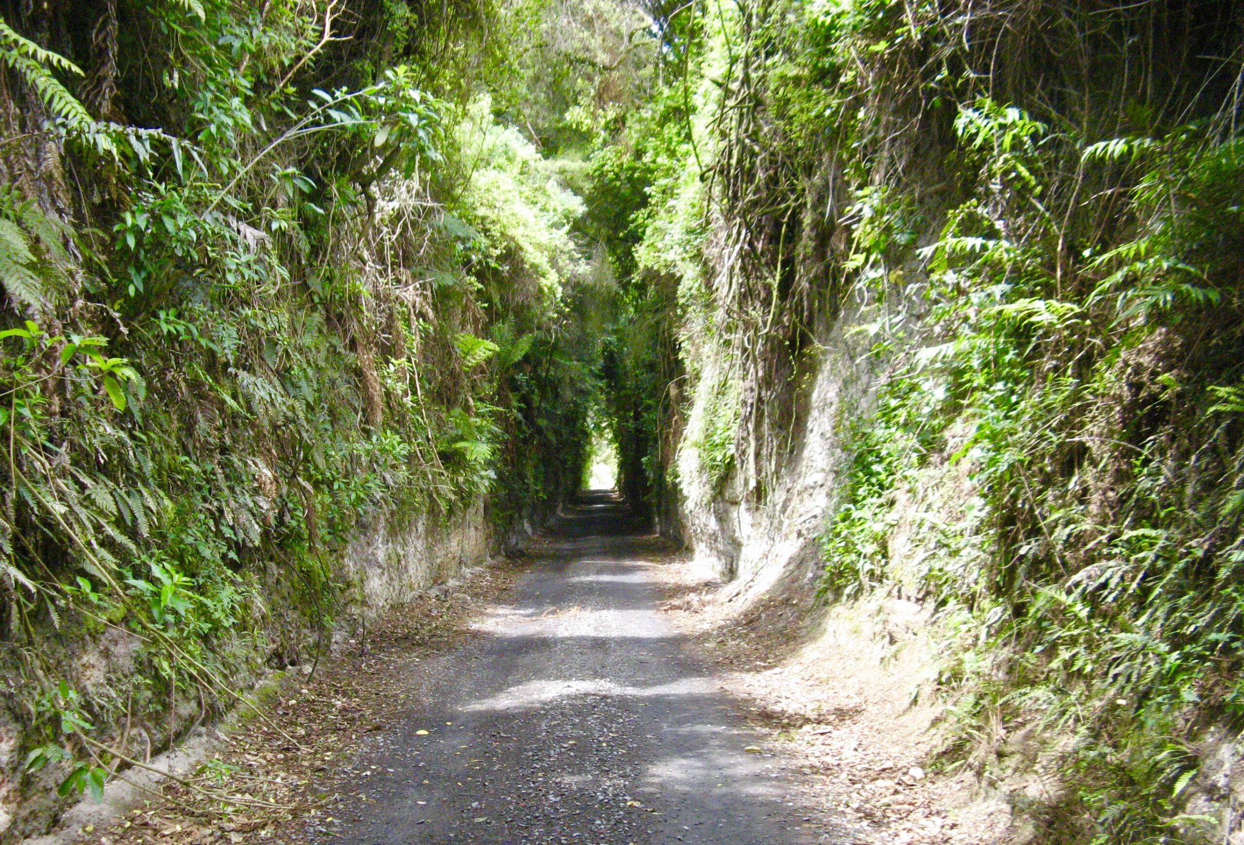
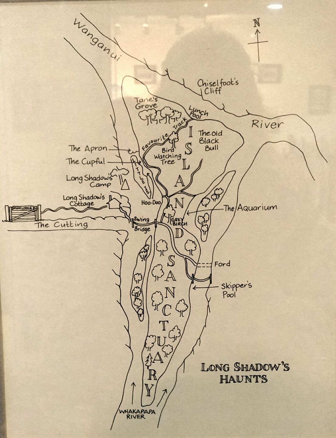
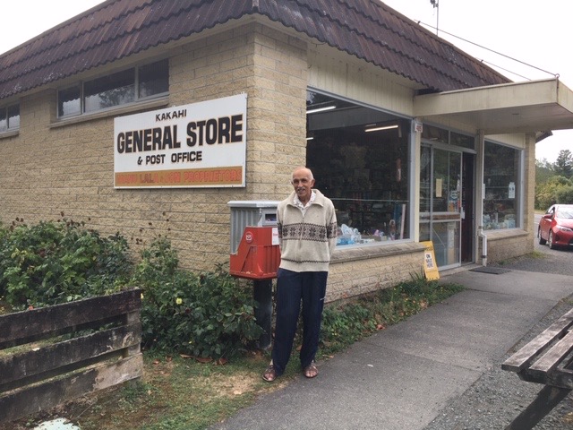
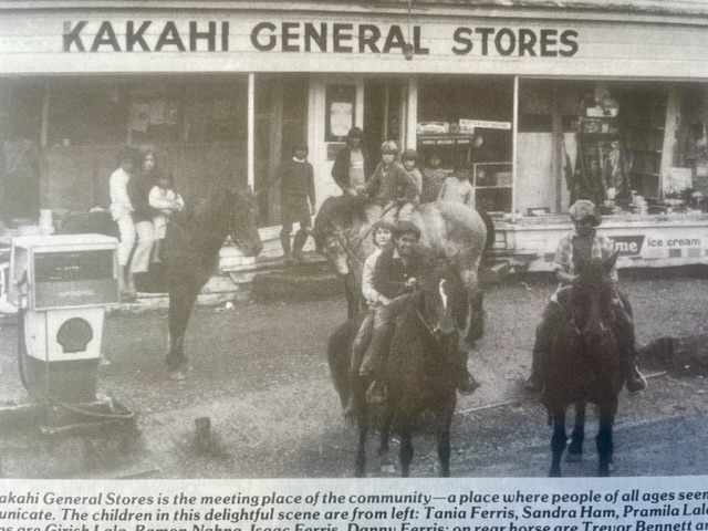
Another example of the huge changes from the Hydro scheme over the past fifty years is the Whakapapa River at Kakahi. The fishing access map below is now of historical value only. The photo above shows “The Cutting,” as indicated on the map. That was originally excavated to provide a future rail link from Kakahi across the Whakapapa River towards Taupo. Long Shadow’s cottage slipped into the Whakapapa.
This region, west of Turangi, provided another memorable episode of commercial greed and the pursuit of the greater good, which almost ruined the Whakapapa River and much of Taumarunui’s future economic prospects. The Whakapapa River contributes to the flow through the Tokaanu Power Station via tunnels to a swamp, which was dammed at the top of the W(h?)anganui River to form a shallow lake now called Lake O, for Otamangakau.
In their defence, if the Crown failed to ruin a classic trout fishing river, then they compensated by creating the best trophy lake in the region. Since then, DOC, the Taupo Fishery Managers, have introduced new regulations that anglers are very concerned could undermine trophy status, unless they are changed. i.e. water temperature was the biggie.
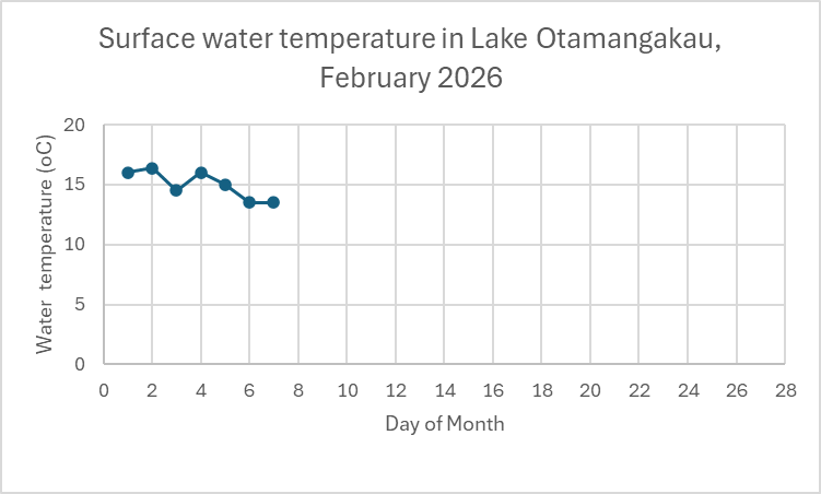
That should be another story, but in case you were also wondering, we cannot resist teasing and sneaking in the latest water temperatures, which were DOC’s main reason for closing the lake in February. DOC maintained that any lake temperature at 20 degrees was too hot and dangerous for trout to survive in February. OK? Watch this space…

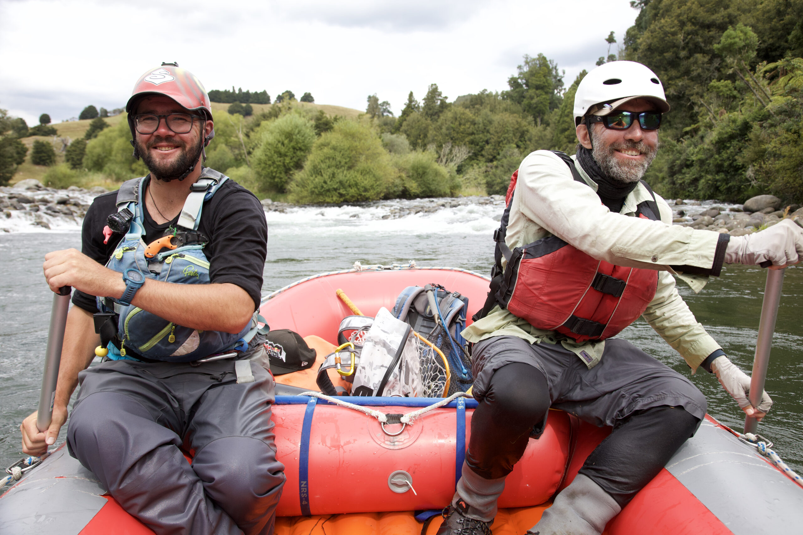
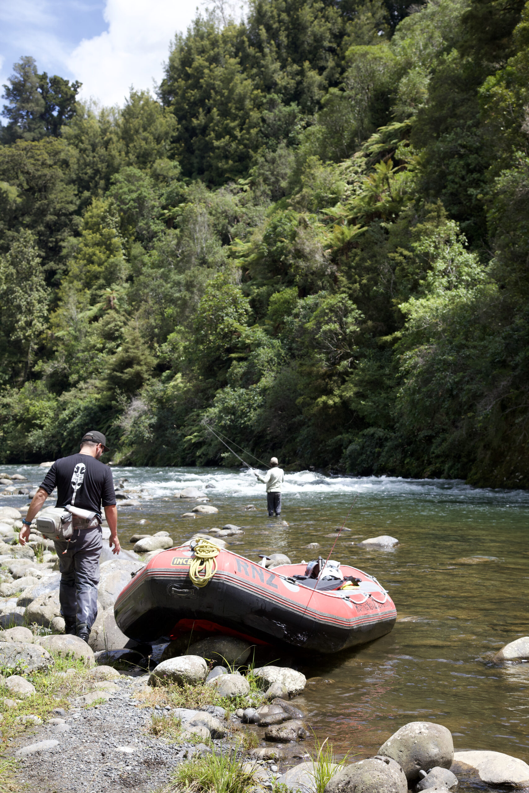
A well-known angler, Peter McIntyre, also internationally recognised as a landscape painter, lived at Kakahi near the confluence with the Wanganui River, and published the wonderful book above, KAKAHI. He took up the challenge and saved the Whakapapa from the original Crown proposal. Fortunately, the world-class fishing has survived, and the reduced flow now provides for excellent raft fishing trips as well – see photos below. These fishy inmates claim it is a far better experience with better trout than the Tongariro, and they bet I would never admit to that…)
Compare the old photos of Kakahi to the present day. It is now a sorry shadow of the past.
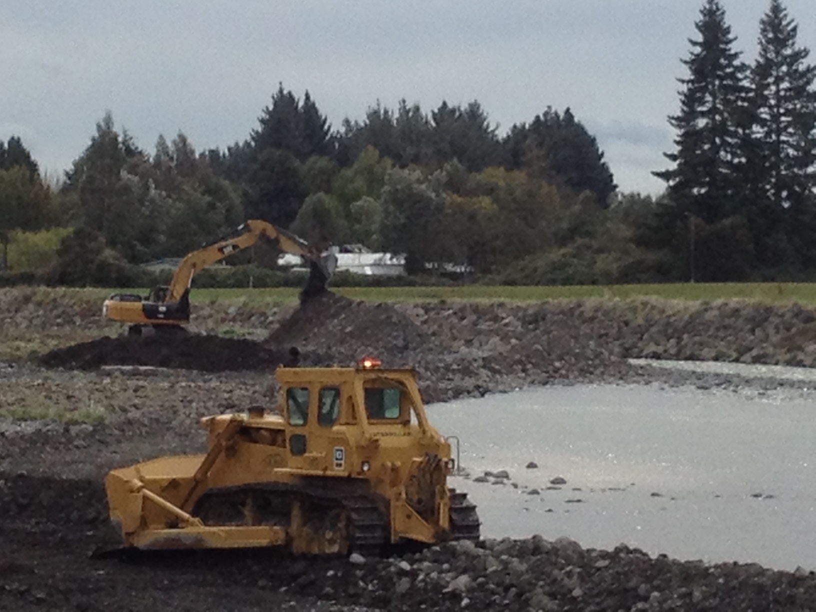
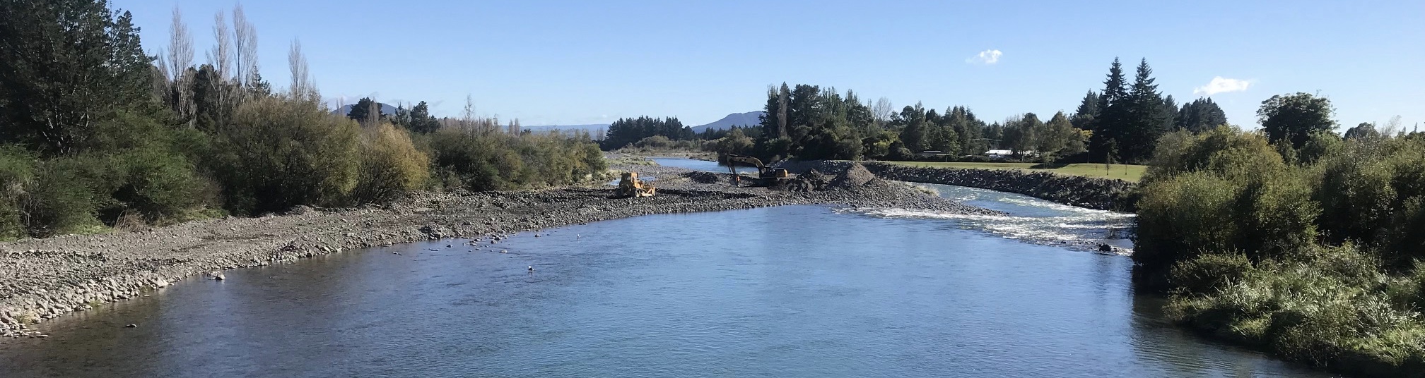
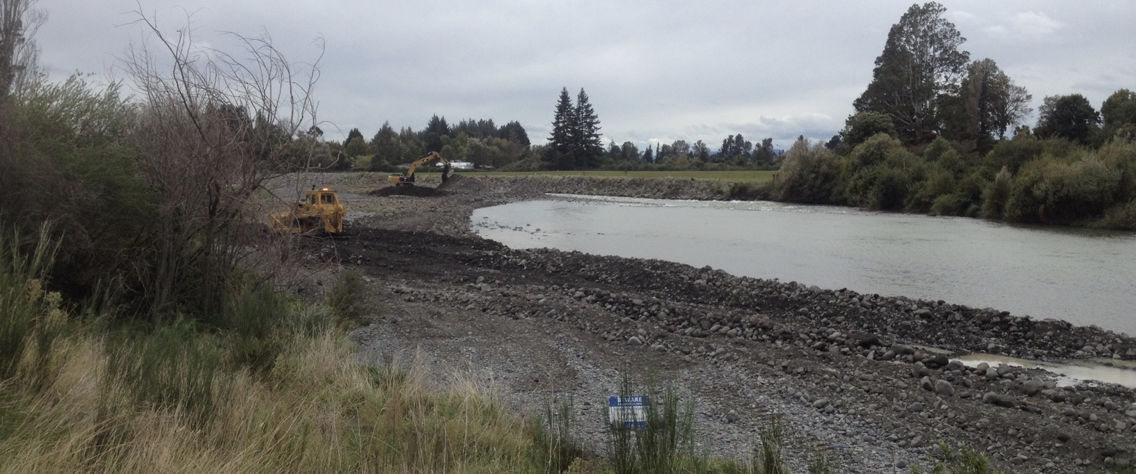
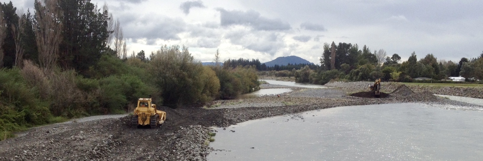
Due to interruptions, by the time the Bridge Pool report reached this stage, it had been derailed and had forgotten the original questions. The 2018 photos below illustrate how nature has changed the Bridge Pool. The previous changes occurred during excavations for the hydro power project that formed the Braids.
Apologies for the TRM 2006 reports on the old Bridge Pool below, read the left-hand column first, as the layout did not copy as planned, but hopefully indicate how the river fishing opportunities keep changing… but rarely improve. That is all part of the charm of trout fishing.
BRIDGE POOL  August 2006 – Bridge Pool Update August 2006 – Bridge Pool Update  The Bridge Pool is practically unchanged for 2006. Still has the most reliable production, week in week out, in the Tongariro River. Unfortunately it is too popular for most fly fishing purists as the usual river ethics and etiquette for wading – i.e. anglers moving through the pool – are often sadly neglected. Anglers looking for more solitude and natural beauty and traditional anglers’ camaraderie would be wise to proceed much further up-river. The Bridge Pool is practically unchanged for 2006. Still has the most reliable production, week in week out, in the Tongariro River. Unfortunately it is too popular for most fly fishing purists as the usual river ethics and etiquette for wading – i.e. anglers moving through the pool – are often sadly neglected. Anglers looking for more solitude and natural beauty and traditional anglers’ camaraderie would be wise to proceed much further up-river.  During the last flood in July it was noticeable that during the higher volume – over 200 cumecs (Cubic metres per second – as recorded on Superfly.co.nz flow chart from Genesis) – the increased river flow began excavating a more direct route from the lower Bridge Pool straight through the Honeypot to Bain Pool. In future years this route could erode further and also bypass the Swirl and Plank Pools.  The Bridge Pool is the most popular pool due to the combination of convenient vehicle access, close parking, easy wading, reliable producer, plenty of back cast room, no snags, plenty of scope for all anglers with wet lines from the LHS beach and nymphing off the elevated RHS rocks. Novices learning how to roll cast should spend time studying the variety of casting skills displayed along the rocks at the end of Herekiekie Street.  Look carefully and you will notice every stone under the road bridge has a tail. Apart from the popular main beach, the area immediately below the bridge should not be overlooked when both sides of the lower bridge pool are too crowded. Trout can usually be polaroided from the bridge. On the LHS the deep gut is easily within novices casting distance immediately and is a reliable producer, particularly popular first up in the morning. Ditto on the RHS, by wading using a woolly bugger or nymph. Look carefully and you will notice every stone under the road bridge has a tail. Apart from the popular main beach, the area immediately below the bridge should not be overlooked when both sides of the lower bridge pool are too crowded. Trout can usually be polaroided from the bridge. On the LHS the deep gut is easily within novices casting distance immediately and is a reliable producer, particularly popular first up in the morning. Ditto on the RHS, by wading using a woolly bugger or nymph.  There is also a lie below the bridge towards the central flow which is often targeted, but wading poles needed. There is also a lie below the bridge towards the central flow which is often targeted, but wading poles needed.  Above the bridge, the RHS is often neglected by most bridge pool anglers where trout have been resting undisturbed during the early morning rush.  Also, further upriver from the bridge often provides good fishing after all the other more popularly named pools have been thrashed. Also, further upriver from the bridge often provides good fishing after all the other more popularly named pools have been thrashed.  We have a few regular devotees who target these out of the way pools and eddies, who have good local knowledge and fish with remarkable success. We have a few regular devotees who target these out of the way pools and eddies, who have good local knowledge and fish with remarkable success.  2006 Naming History 2006 Naming History  The naming history of this area above the bridge is as controversial as the river history. Remember that the river has changed its course over the years and the bridge location has moved up-river. The naming history of this area above the bridge is as controversial as the river history. Remember that the river has changed its course over the years and the bridge location has moved up-river.  Starting at the Lonely Pool, this name was coined after 1955 when the Birches swing bridge was built and it was necessary to make a long walk down-river to fish the Lonely. This was when the pool was located against the stop bank, below the walkway, where the river is now a flood by-pass. Starting at the Lonely Pool, this name was coined after 1955 when the Birches swing bridge was built and it was necessary to make a long walk down-river to fish the Lonely. This was when the pool was located against the stop bank, below the walkway, where the river is now a flood by-pass.  Then there was the Groin Pool located immediately up-river and fished from the LHS, named on Barry Greig’s 1983 map and Lyn Lloyd’s maps, confirmed in notable books like Tony Jensen’s Trout of the Tongariro and Hicklings classic Freshwater Admiral. \ Prior to this it was known as the Weir Pool, named by R. L. Begg in the NZ fishing and Shooting Gazette, in June, 1936, and prior to that it was named as the Daisy Pool on the 1928 map in Barbara Cooper’s booklet – Pools of the Tongariro. However, as the bridge was then further down-river from the present location, the Daisy Pool was where the Bridge pool is now. Then there was the Groin Pool located immediately up-river and fished from the LHS, named on Barry Greig’s 1983 map and Lyn Lloyd’s maps, confirmed in notable books like Tony Jensen’s Trout of the Tongariro and Hicklings classic Freshwater Admiral. \ Prior to this it was known as the Weir Pool, named by R. L. Begg in the NZ fishing and Shooting Gazette, in June, 1936, and prior to that it was named as the Daisy Pool on the 1928 map in Barbara Cooper’s booklet – Pools of the Tongariro. However, as the bridge was then further down-river from the present location, the Daisy Pool was where the Bridge pool is now. |  (Tourists admiring the spawning runs passing under the bridge) (Tourists admiring the spawning runs passing under the bridge)  The existing Lower Bridge pool location was previously known as Vera’s Pool, named after Vera Blair who fished here frequently. This pool disappeared after the big flood in 1958. The existing Lower Bridge pool location was previously known as Vera’s Pool, named after Vera Blair who fished here frequently. This pool disappeared after the big flood in 1958.  Bridge Lodge was originally built in 1931 and has gone through many changes since.  September 2005 – Bridge Pool Update…  Since our original report, fishing pressure on the Bridge Pool has changed significantly with mainly traditional wet lining on the LHS now outnumbered by roll casting nymphers off the rock wall on the RHS. Interesting… Since our original report, fishing pressure on the Bridge Pool has changed significantly with mainly traditional wet lining on the LHS now outnumbered by roll casting nymphers off the rock wall on the RHS. Interesting…  June 2005 – Bridge Pool Report The conveniently located Bridge Pool remains a really great holding pool after the 2004 flood. It¹s the favourite of TRM inmates – John, George, & Horty, regulars here for over forty years This report was postponed awaiting completion of the new stop bank, with 50,000 m3 of gravel excavated. To prevent further erosion, more dumping of quarried rubble to reinforce the high bank on the RHS is still being completed (as at 25 June) down river from the end of Herekiekie Street. This Pool was previously referred to as the Hut Pool – wiped out in the 1958 flood and renamed Lower Bridge Pool, to differentiate from the Bridge Pool immediately under the bridge – hopefully we all know where the daily scrum of anglers are seen from the bridge. This big pool continues to be arguably the most reliable producer over the last decade. Usually 5 to 10 or more anglers confirm that every morning. Recent site works appear to have mainly changed vehicle access routes but more determined anglers still find a track through – confined to 4WD or Hertz vehicles.  This pool appears to have its own fishing etiquette (?) rules. Usually anglers proceed to their favoured spot and anchor there until their arms get too tired from pulling in trout or until the breakfast bell tolls. Do not expect any procession of anglers to shuffle along to give up their spot – they probably have a mortgage on it. The Pool is usually dominated most mornings by regular wet liners, each with their preferred bait – start before sparrows with Black Dogs, once the sun sparkles on the water change to large Olive Woolly Buggers, if they don¹t work, switch to traditional standby Red Setters, if the strong green flow is too clear, substitute Yellow Mallards, if too milky try Fuzzy Wuzzys or Rabbits, etc. If still no action, add a large muppet behind whatever. This pool appears to have its own fishing etiquette (?) rules. Usually anglers proceed to their favoured spot and anchor there until their arms get too tired from pulling in trout or until the breakfast bell tolls. Do not expect any procession of anglers to shuffle along to give up their spot – they probably have a mortgage on it. The Pool is usually dominated most mornings by regular wet liners, each with their preferred bait – start before sparrows with Black Dogs, once the sun sparkles on the water change to large Olive Woolly Buggers, if they don¹t work, switch to traditional standby Red Setters, if the strong green flow is too clear, substitute Yellow Mallards, if too milky try Fuzzy Wuzzys or Rabbits, etc. If still no action, add a large muppet behind whatever.  Sometimes all are effective to suit changing climatic conditions. Just experiment to see what the trout have on their menu each visit. Some regulars will bet the ranch on their home made special custom designed lures which defy written description. There are not many days when this pool does not produce – but get there early! By my breakfast time many anglers have been there, done that, with their catch already cleaned in the freezer. Jared (x Sporting Life) has the solution for beating the crowd, although surprisingly few appear to take advantage? Sometimes all are effective to suit changing climatic conditions. Just experiment to see what the trout have on their menu each visit. Some regulars will bet the ranch on their home made special custom designed lures which defy written description. There are not many days when this pool does not produce – but get there early! By my breakfast time many anglers have been there, done that, with their catch already cleaned in the freezer. Jared (x Sporting Life) has the solution for beating the crowd, although surprisingly few appear to take advantage?  Constant pressure from fast sinking deep trawling wet lures appear to push the shoals over to the RHS so smart nymphers should prepare with a hearty breakfast first, read the morning paper, then amble on down in office hours to the end of Herekiekie Street armed with long leaders and heavy bombs to run a nymph along below the bank . You need to be agile and might need a landing net. Constant pressure from fast sinking deep trawling wet lures appear to push the shoals over to the RHS so smart nymphers should prepare with a hearty breakfast first, read the morning paper, then amble on down in office hours to the end of Herekiekie Street armed with long leaders and heavy bombs to run a nymph along below the bank . You need to be agile and might need a landing net.  Check it out first with polaroids – trout can often be seen sulking along this RHS just out of reach of the deep lures. Or on balmy summer evenings, try a small dry fly through the shallows on the LHS as trout are seen moving back to wait for the hatch as soon as wet liners depart. The pool immediately down river from the bridge is often fished with a deep nymph from below, off the bridge pier, where again longer traces and heavier bombs do the most business. This spot is not recommended in summer when local kids have reserved this pool for jumping & diving practice from the bridge above for the amusement of SH1 traffic. If all the fishy excitement is too much strain on the nerves, some relief is available in the form of the unisex loo in the main road car park – for a memorable melodious musical moment in waders it deserves a highly recommended classification. (Since demolished by Council) Check it out first with polaroids – trout can often be seen sulking along this RHS just out of reach of the deep lures. Or on balmy summer evenings, try a small dry fly through the shallows on the LHS as trout are seen moving back to wait for the hatch as soon as wet liners depart. The pool immediately down river from the bridge is often fished with a deep nymph from below, off the bridge pier, where again longer traces and heavier bombs do the most business. This spot is not recommended in summer when local kids have reserved this pool for jumping & diving practice from the bridge above for the amusement of SH1 traffic. If all the fishy excitement is too much strain on the nerves, some relief is available in the form of the unisex loo in the main road car park – for a memorable melodious musical moment in waders it deserves a highly recommended classification. (Since demolished by Council) |