Update from Department of Conservation – Tongariro
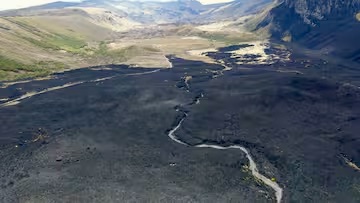
It’s been an emotional week for our team as we supported the response to the large fire that impacted almost 3000 ha of Tongariro National Park and caused the closure of the Tongariro Alpine Crossing and Mangatepopo (Ditch) Track.
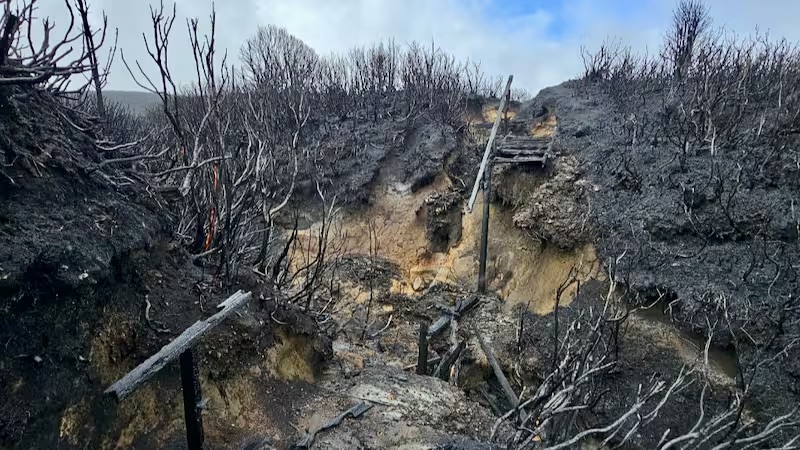
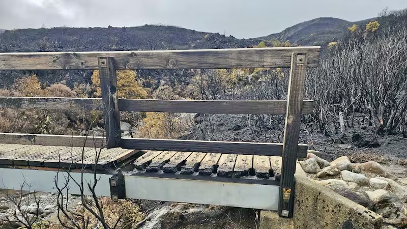
While Ngāti Hikairo ki Tongariro applied a rāhui on an area of the park, including Mangatepopo Road and the area towards, and including Whakapapa Village, our teams have been out assessing damage and looking to dampen down any hot spots. Most impacted has been the Mangatepopo Track – often referred to as the Ditch Track due to its nature, where natural water courses have forged a track with slightly more character (!) than some of our others in the park.
We were saddened to see how the fire has ravaged through this area, and it’s safe to say this track is likely to be out of action for some time. Mangatepopo Track is also part of the Tongariro Northern Circuit Great Walk, so we’re keen to get things sorted as soon as possible, but our assessments will take a long time to complete before we can get stuck into remediation work.
Fire and Emergency NZ are yet to determine the cause of the fire and investigations are still underway, and the rāhui and track closures remain in place. We will update everyone as soon as we can on when we might be able to open our tracks for you to enjoy. In the meantime, please keep respecting the rāhui so this special whenua can heal, and so our team can continue to do their important work.
SWMBO suggests that with the future access to the Tongariro Crossing closed from fire damage, it is time to plan, to look beyond the Tongariro Crossing, to consider some other challenging trails for summer holiday hikes in this region. TRM’s previous post dated has been updated as follows:
TRM’s blog’s recently showed a brief view of the Kaimanawa views from the Umukarikari Track. This generated more interest with two distinctly different points of view. Most wanted more info but a few asked us not to post these tracks on social media as there are already too many tourists spoiling the tranquility and the hunting… TRM do not recommend them during “the roar” around Easter. The original post read:

“If the Kaimanawa tracks were in the South Island they would qualify for funding as another Great NZ Walk – but here in Turangi, they are just another track.”

As TRM is committed to the tourist accommodation business, SWMBO (She Who Must Be Obeyed manages everything touristy at TRM) can only apologise to local hunters. There are plenty of other remote tracks which offer good hunting closer to Turangi – which tourists will never find. But what is suggested by readers is true. These tracks should be part of a multi-day experience.
Now a new bike trail has being developed up into the Kaimanawas, offering a 25 km downhill experience, so it is too late to try to keep them secret. We understand a resource consent application has been submitted to link this new downhill bike trail extended north to link up with existing trails starting with the Tree Trunk Gorge trail. Linking combined hiking/biking trails in this region are long overdue.
TRM’s BIG DAY OUT for bikers links ten trails from Tree Trunk Gorge back to Turangi.

Now we are into the warmer summer months there is a lot more interest in these remote tracks in locations beyond the usual popular over-crowded Tongariro Crossing or the popular Northern Circuit type tracks. For many years TRM has been quietly promoting an extraordinary bike track in this area.

TRM calls it The Big Day Out. We cannot report too much without spoiling the surprises. Generally it follows some of the trails and roads developed for the Tongariro Hydro Power Scheme over sixty years ago. To protect its exclusive charm, SWMBO’s route notes are for TRM inmates only.

It extends up to fifty km. depending on the selected route and covers everything with a huge variety including two DOC-managed tracks, remote scenic backcountry unsealed roads, a mix of mature native bush and forestry, upper Tongariro river dams, mainly downhill, with possibly the most unique unexpected lunch break, which we cannot advertise. Long after bikers have forgotten where the track went, we promise they will remember the drink stop. We know from their photos…

But I must not get side-tracked as this blog is supposed to tell you about some of the other little-known scenic hiking tracks available. These are listed in no particular order with the only pre-requisite needed for tourists to bring with them is fine weather and a PLB! (Personal Locator Beacon). TRM cannot afford to lose inmates.

1 Umukarikari Track above, 4.7 km, climb to 1593 m., 2-3 hours each way, return track through bush track up above the exposed snow line to great distance views over Lake Taupo and the National Park.
2 Urchin Track, 6.6km, climb to 1391m., 3-4 hours each way, advanced fitness rating!
3 Tree Trunk Gorge, 12 km return, 2-3 hours, advanced fitness crossing three streams so make sure weather is dry.
4 Tama Lakes (extension to the popular Taranaki Falls walk,) 17km., 5-6 hours, exposed upper lake altitude 1440 m located in a wind funnel.

5 Mt. Tihia, 4.6km., 3-4 hours up 437m, down 550m if you can find the overgrown loop track, good views.

6 Lake Rotopounamu, 5 km, a warm-up 2 hours level loop around a hidden lake may be too easy and too popular for many?
7 Then there is the “Daddy of them all” – TRM’s top pick for a really adventurous rewarding challenging Big Day Out. See the following brief video: