Flood protection OR metal extraction? You decide…

TRM has recently received many more complaints from anglers fishing down the lower Tongariro River where WRC (Waikato Regional Council) have steadily wrecked the natural river flow year after year. For anglers concerned about the continuing destruction of access tracks and the likely effects of their river works on fishing, then some knowledge of the background should be compulsory reading to understand the issues. Many anglers have reiterated this would never happen elsewhere in a

Note the proposed works on the earlier 1995 maps are headed “METAL EXTRACTION AND FLOOD CONTROL”.

It is a big read so make a strong cup of tea first…

First, following background from the ‘historic’ official 1995 Turangi Report…
Turangi Township: Further Developments
7.3 THE TONGARIRO RIVER A brief description
In its lower reaches where it flows past the Turangi township, the Tongariro River is an inherently unstable, braided river made up of meandering channels and gravel banks. With a large catchment area, it was, in its natural state, also subject to periodic floods which filled the whole bed and overflowed into the swamp lands between Tokaanu and Motuoapa (fig 21).
The instability of the river and its propensity for flooding had to be taken into account in the design of both the township and the Tokaanu power project. In 1958 a major flood had inundated the northern end of the Turangi village, breaking through on the left bank into Hirangi Stream and scouring out a new channel which came to be known as the ‘Hirangi Arm’. At the junction of Hirangi Stream and the Tongariro River, an area later known as ‘Bennion’s Bend’, the flood waters broke through to the Tokaanu swamp lands and were reported as flowing three feet deep over Awamate Road (B5(a):81). The name ‘Awamate’ literally means ‘dead river’, and the road marks a former course of the Tongariro. In local Maori tradition, it is said that the taniwha Huruhurumahina was responsible for turning the river to its present course.
In the early stages of the planning for the Tokaanu power project, Sir Alexander Gibb and Partners had proposed that a ‘drainage channel’ be dredged through the Tokaanu swamp lands to carry any flood waters from the Tongariro River directly to Lake Taupo. The main concern was to protect the eastern margin of the tailrace. This proposal was later dropped and protection works were put in place on the eastern
7.3.2 Trout fishing interests
The potential for conflict with trout fishing interests was greatest when the Tongariro River fishery was threatened by the Ministry of Works’ proposal to extract metal from the riverbed for the Turangi township and the Tokaanu power project. The Wildlife Service of the Department of Internal Affairs was responsible for the control of the trout fishery. The District Conservator of Wildlife, Pat Burstall, took an active role in a series of meetings on flood control and the proposed metal extraction which were held in late 1964 and 1965 between representatives of interested Government departments, the Waikato Valley Authority, and the Taupo County Council. At a meeting on 10 December 1964, Burstall made it very clear that anglers did not want to see fishing rivers disturbed. Gibson, in turn, gave an assurance that ‘there would be no destruction or despoliation of the fishing’ (B5(a):51).

TONGARIRO RIVER FLOOD CONTROL PROPOSALS
Trout fishing had been identified by Government officials at an early stage as one of the potentially controversial issues to be considered. However, the early reports of Gibb and Partners had identified the gravel bed of the Tongariro River as the most economic source of aggregate both for roading and for making concrete at the Tokaanu power project. The issue was not whether Tongariro River gravel should be used, but how to extract it with the least disturbance to the fishery. At the 10 December meeting, Burstall stressed that the river should be protected wherever possible and pointed out the economic benefits which fly fishing brought to the region (B5(a):52-53). Indeed, the number of trout fishing licences issued in the Taupo district increased from roughly 10,000 in 1948-49 to about 50,000 in 1959-60 and 77,000 in 1983-84.
If, therefore, the Ministry of Works were to extract most of the gravel that was required for the township and the power project from the Tongariro River bed, agreement would have to be reached with the Waikato Valley Authority on flood control matters and the Wildlife Service on the protection of the trout fishery from unnecessary disturbance. The strategy that the Ministry evolved was to view the metal extraction, to be undertaken mainly by contractors, as a significant contribution to both flood control and the improvement of the Tongariro River bed by the stabilisation of the channels through which it flowed. At the 10 December meeting, Gibson suggested this, and Burstall conceded that the Tongariro River would be improved for anglers in several areas by the extraction of metal from the bed, which would include the diverting of the river back to its old course prior to the 1958 flood (B5(a):52—53).
Through 1965, meetings of Ministry of Works engineers with other Government officials and representatives of the Waikato Valley Authority and the Taupo County Council focused on the legal and technical issues relating to the extraction

Turangi Township Report 1995
7.3.3 The metal extraction programme
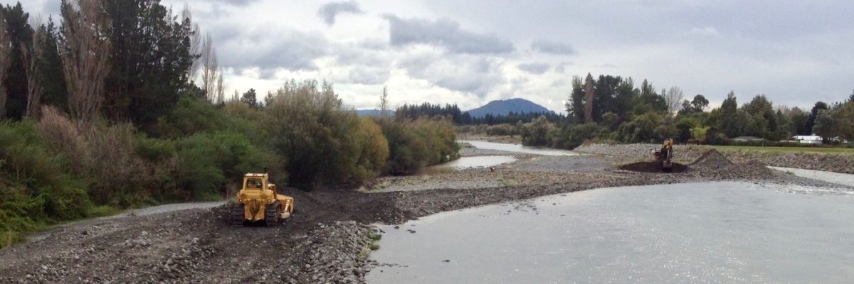
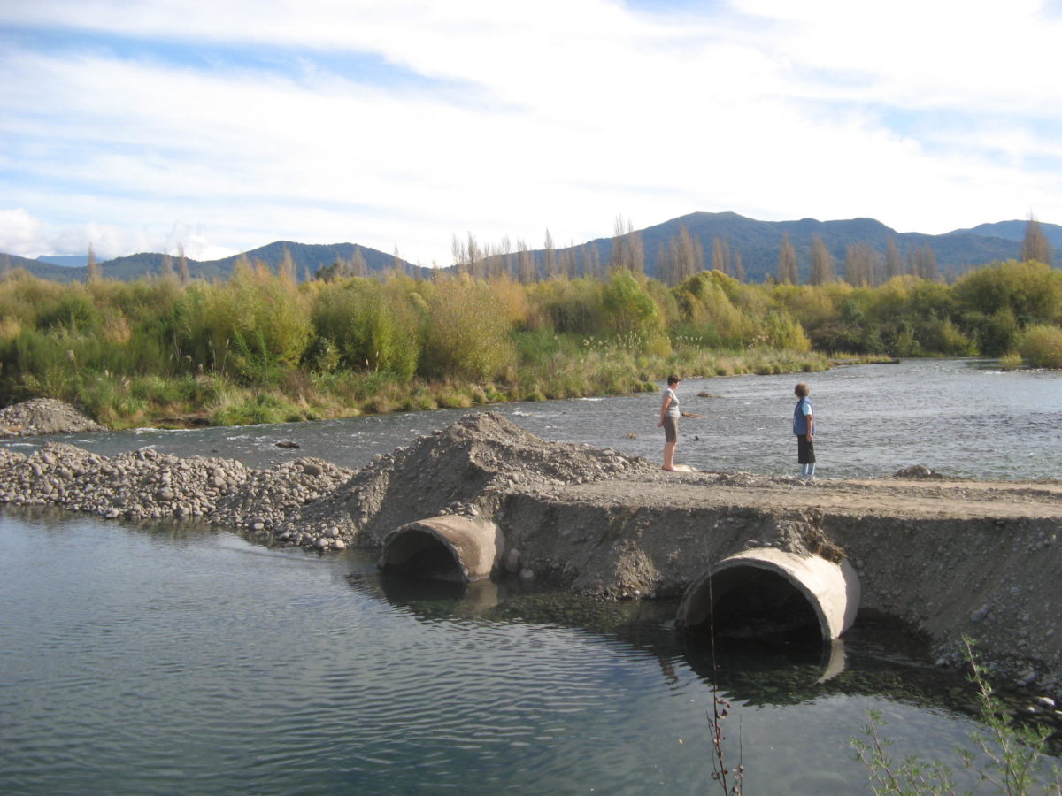
The Ministry of Works’ metal extraction programme, in effect, became part of the Waikato Valley Authority’s flood control scheme for the Tongariro River (fig 22). Metal extraction began in 1964 in the Swirl Pool area and in the metal pit between Herekiekie Street and SH1. Throughout 1965, excavation was continued in the ‘flood relief channel’. Strippings and other material unsuitable for construction purposes were used to block off the Hirangi Arm of the river, and this work was completed by mid-1966. With the development of the Turangi township, the Log Crossing Road access to the river was no longer used and a new haul road was put in across the Waipapa 1d 2b 3b block. Some three acres of this land, which was leased and farmed by Te Reiti Grace, had already been excavated for metal. The new road became the principal access route to the metal extraction area through the 1960s. By the early 1970s, the metal extraction had moved downstream to a Maori-owned island which was part of the Hautu 3e4a block (fig 22 inset).
Strippings were used to build up levels in the vicinity ofBennion’s Bend and a stopbank downstream of the haul road carried a ‘fishermen’s access road’. Part of the Ministry of Works’ agreement with the Wildlife Service was to allow anglers access to their favourite pools along the haul roads. Initially, Bailey bridges were used to span river channels, although the bridge over the Hirangi Stream was replaced in 1972 by a culvert. Subsequently, the culvert became blocked, causing flooding upstream. Complaints about this from the Rawhiti Rangataua family led to the removal of the culvert by the Ministry of Works in 1985, but not without some remonstrance from Pat Burstall on behalf of anglers (B5:44-45). Whatever informal agreement may have been reached between the Ministry of Works and the Wildlife Service, no agreement with the Maori owners of Waipapa 1d 2b 3b ,whose land was crossed by the haul road, had been reached to allow for permanent access for anglers. The Ministry of Works had entered the land, relying on the
1958 Order in Council, but this did not give any powers to provide permanent public access. There were proposals to take the haul road but these were not implemented, and Waipapa1d2b3b remainedMaoriland,althoughtheamountofcompensationpayablefor its use, the metal extracted, and the restoration of the land to pasture became issues for subsequent argument with the Te Rangi family and the lessee, Te Reiti Grace. The excavation of metal from the Maori-owned island, part of Hautu 3e4a ,also became the subject of dispute and proceedings in the Supreme Court in 1976. These compensation issues are considered further in chapters 14 and 19.
7.3.4 The Tongariro River control scheme
In June 1966, the Waikato Valley Authority produced a ‘Tongariro River Control Scheme’, the main objectives of which were the protection of the Tokaanu tailrace and Turangi township from flooding; the retention of river features for the benefit of fishing interests; and the acquisition of any land which was required for flood protection works or was adversely affected by them (B5(a):97). The scheme, designed for a flood o f the magnitude of the 1958 flood, included building stopbanks on both banks of the lower reaches of the river downstream from the Turangi village. Although at this stage it was estimated that some 700,000 cubic yards of metal and overburden would be excavated from the flood relief channel, it was also noted that infilling would continue as more gravel was carried by the river into the excavated areas. It was also assumed that the Ministry o f Works would make a substantial contribution to the river protection works. However, the Ministry was interested solely in protection work on the left bank and considered that stop banking was only necessary in the Awamate Road area for the protection of the oxidation ponds. In chapter 9, we consider the oxidation ponds in more detail. The ‘riprap protection works’ to be put into the eastern berm of the tailrace were considered adequate without further stop banking.
On the right bank ofthe river, it was considered that stopbanks should be put in between Turangi Bridge and De Lautour’s Pool but that a spillway could be built here to allow flood waters to enter directly into Stump Bay. Lands to be taken for river protection works on the right bank were identified and, after several modifications to the boundaries, were taken by proclamation in the mid-1970s.5In 1987 part of the land taken in 1975 was returned to Maori ownership when the 1975 proclamation was revoked.
Tuatea Smallman commented in his submission to the Tribunal:
This island was also apparently given back under that Gazette notice but of course the Ministry of Works had already excavated the whole island out of existence. The problem is that the land we were given back used to be pasture land but is now covered in light scrub . . .
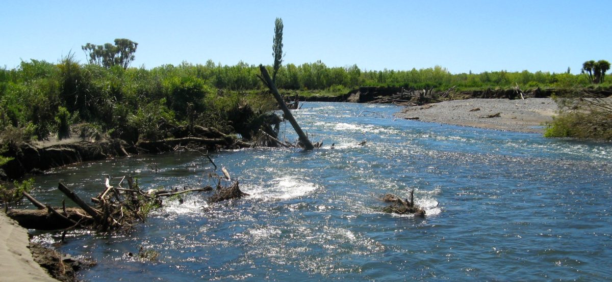
The removal of the island has caused massive damage, because there is now continuous flooding. . .
Erosion of the river bank has occurred, along with silting of the riverbed and favourite fishing pools. The flooding has damaged the urupa where our great grandmother, Marotoa Takinga, a direct descendant of Tuwharetoa, [who] was struck by lightning and [was] laid to rest. We cannot protect the resting place from the water which is a cause of sorrow to us.
This flooding situation came about because to remove the island without losing any of the metal a diversionary canal was excavated into Hautu 3e4a to take the major flow of water. The diversion was never cut off or filled in. (A23:8)
When the first notice of intention to take lands on the right bank was issued in 1969, the Tuwharetoa Maori Trust Board’s solicitor, Russell Feist, wrote to the Minister of Works on behalf of the Maori owners:
It appears from discussions with representatives of the [Waikato Valley] Authority that their proposals have been largely influenced by requests from fishing interests not to interfere with the trout fishing on the river. The Tuwharetoa people have no wish to interfere with any fisherman’s paradise, but I would seriously question whether this is a factor that is relevant when it involves the compulsory taking of land for purposes of a public work. I had the distinct impression from the meeting at Hamilton that were it not for the fishing interests, the Authority’s proposals would follow a completely different course. (B5(a):173)
7.3.5 Maori participation not sought
There is no doubt that the trout fishing interests were an influential group, whose concerns were diligently pursued by the District Conservator of Wildlife, Pat Burstall. It is also noted that in the meetings on the flood control of, and metal extraction from, the Tongariro River there was no Maori participation – from either the Department of Maori Affairs or the owners’ representatives – to consider matters that were of some concern to Maori landowners on both sides o f the river.
The taking of lands for river protection purposes along the northern boundary of the Turangi township has remained a sore point with the local people. Eileen Duff explained in her submission to the Tribunal:
Whereas our family land [Waipapa 1f 3b 2b 3b ] formerly had a natural connection with the Hirangi Stream and with the Tongariro River, subsequent actions by government have cut us off from that connection. This causes us a lot of grief.
The thing that galls me is that nothing has ever been done to the land that was taken to effect protection of the land from the river. Big wide bits of Maori land were taken all along that stretch of the Tongariro River, but no works have ever been done to stop the river encroaching.
In a letter to my Uncle George of 6 June 1947 . . . the office of the Minister of Native Affairs said that the land needed to be taken for river protection purposes because otherwise ‘many land owners both Maori and Pakeha’ would lose land to erosion. But it is really obvious from looking at the Taupo County [planning] map that when the land abutting the river was European land, much less land was taken. Those skinny strips taken from European land owners have been justified by building flood control barriers, so less land was needed. When it was Maori land, they just took a big wide strip, and then did nothing to it. The conclusion is inevitable that taking larger quantities o f Maori land was thought to be quite acceptable. (A22(2):2—4)
Further areas of Waipapa 1f3b 2b 3b were taken in 1966 and 1971. Mrs Duff continued:
Although the Gazette Notice says that the land taken from us in both 1966 and 1971 was for the Establishment and Development of Turangi Township, a good deal of what was taken is now in the hands of Department of Conservation and was never used for the establishment o f the township.
We still regard the areas [taken] as our family land, even though we know that legally speaking others have title of it. Morally and spiritually, it is ours, and we still regard ourselves as the kaitiaki of it. As a result, what has happened to the land since it passed out of our ownership has affected us deeply. (A22(2):5-6)
7.3.6 Legal status of riverbed unclear
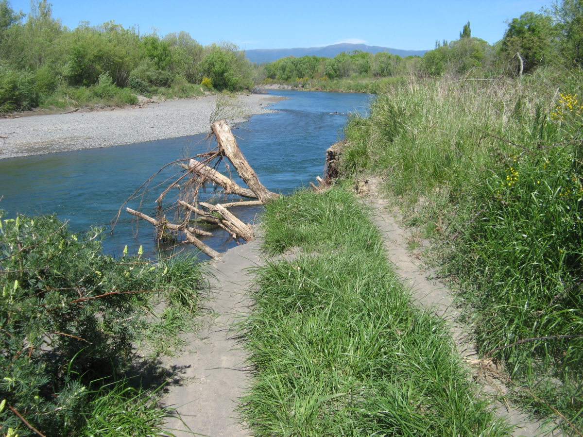
The legal status ofthe riverbed was not clear. As figure 22 illustrates, the Tongariro River had not remained in its legal bed as defined by survey in 1928. In March 1965, a Department of Lands and Survey representative at a meeting of officials with the Waikato Valley Authority and the Taupo County Council noted that the Crown Law Office’s opinion was that the definition of a riverbed remained ‘the same as it was at the date of proclamation notwithstanding subsequent changes in the river course’. If the Crown wished to own all of the present bed, he noted, a new proclamation would be required, which would lead to substantial compensation claims (B5(a):60). In effect, the Crown did acquire all the new riverbed areas in the vicinity of the Turangi township. In 1939 a ‘river protection reserve’ on the left bank had been taken under the Public Works Act 1928.8 Lands between this reserve and the old SH41 were taken under the Turangi Township Act 1964, although only part of this area was used for township purposes, mainly as a residential area. All the lands below the terrace on which the houses were built, including the Hirangi Stream, are effectively, if not legally, part of the Tongariro River bed. The area is low-lying, subject to flooding, and cannot be built on. It is covered in scrub, interspersed by stream channels, backwaters, and gravel banks, and there are vehicle and foot tracks through it which provide access for anglers.
In the 1920s, negotiations between the Crown and Ngati Tuwharetoa led to an agreement, embodied in section 14 of the Native Land Amendment and Native Land Claims Adjustment Act 1926, in which the public were granted access to the Lake Taupo fishery and the bed of the lake was vested in the Crown. Sections 14 and 15 provided for compensation in the form of an annual payment and a share of the fishing licence revenue, and this was to be administered by the Tuwharetoa Maori Trust Board, which was set up for this purpose. The beds of rivers and streams flowing into Lake Taupo were subsequently declared Crown land by proclamation on 7 October 1926.9
The compensation awarded for the bed of Lake Taupo did not include the tributary rivers and streams, but this was determined in December 1948 by the Lake Taupo Water Claims Compensation Court. The claims were not settled earlier because of a doubt over interpretation, which was settled in section 8 of the Native Purposes Act 1946. The Court stated:
Without question the right that the Maori owners enjoyed prior to the Proclamation of reserving to themselves or their grantees the right of access to fishing waters was a right of very considerable value. The difficulty before us is to assess the value of this right as it existed prior to the passing of the Act of 1926.
The Tongariro River from the junction of the Whitikau Stream to its mouth in Lake Taupo was listed in the 1926 proclamation, but the Tokaanu River was not. In the 1920s, local Maori derived some income from fees charged to anglers for access to, and the letting of camp sites on, the Tongariro River.
In 1965 the Maori Land Court was asked to determine the beneficiaries of the Tuwharetoa Maori Trust Board. Although the court was not required to consider ownership as the basis of a Maori freehold title to the lake, it noted that in other cases, such as those dealing with Lakes Rotoaira and Waikaremoana, ownership had been determined on the basis of ownership of riparian blocks around the lake. On this basis, the roll of beneficiaries of the Tuwharetoa Maori Trust Board is based on descent from owners listed in the blocks, as determined in the original investigation of title by the Native Land Court, which are adjacent to Lake Taupo, the Waikato River downstream to and including Huka Falls, and the tributary streams and rivers listed in the 1926 proclamation. All these are collectively known as ‘Taupo waters’.
On 28 August 1992, a deed of agreement between the Minister of Conservation and the trust board was signed and, following ratification of the agreement by Tuwharetoa beneficiaries, it was confirmed by the board on 4 February 1993. The deed acknowledged the earlier negotiations and agreements set out in the 1926 Act and currently provided for in section 10 of the Maori Trust Boards Act 1955. The trust board sought the return of title to the beds of Taupo waters, asserting that it was not intended in the original negotiations, which were concerned with fishing rights, that title be vested in the Crown. Under the agreement, the beds were revested in Ngati Tuwharetoa; the public’s freedom of entry to and access upon the waters (including their beds) was preserved; and their management was to be shared between the Crown and Ngati Tuwharetoa. Half of the members of the management board were to be appointed by the trust board and half by the Minister of Conservation, who would ‘represent the public interest’.
On 22 September 1993, at a special sitting of the Maori Land Court at Tapeka Marae in the Waihi village, an application by the Minister of Lands to vest in the trust board ‘the beds of Lake Taupo and the Waikato River up to and including the Huka Falls’ was heard under section 134(e) of Te Ture Whenua Maori Act 1993. The application noted that the agreement also included tributary streams and rivers which are part of Taupo waters, but that these would be the subject of ‘a separate application upon completion of technical investigations’. Specifically excluded from the Tongariro River bed were the section within the ‘Tongariro Hatchery Camping Ground’ and the islands in the river which were not taken by the Crown in 1926.
The technical investigations which have delayed the revesting of the beds of the streams and rivers include the requirement for new surveys to determine the actual location of the riverbeds. As we have seen with regard to the section of the Tongariro River reviewed here, the river has strayed well outside its legal bed, and even the efforts of the Ministry of Works in the 1960s and 1970s have not entirely succeeded in confining it to its surveyed route of 1928. We leave the specific task of defining the riverbed to the technical expertise of surveyors, but venture to suggest that, given the behaviour of the Tongariro River in recent decades, a broader definition than that used in 1928 needs to be applied.
7.3.7 Changes to the flow regime
A related technical matter is

WRC on Tongariro works programme

Email received 18 August 2018 and TRM response below:
Hi Ross,
In addition to the proposed Tongariro River Flood Scheme 2018/19 works distributed to stakeholders on June 29th.
Allan (Zone Manager) and myself (River Management) are hosting a public drop in session to discuss the 2018/19 proposed works programme. This is a good chance for the whole community to have an informal chat about any questions, suggestions and concerns that stakeholders have about proposed works and general river initiatives and programmes at this early stage. We are looking to display a map of the scheme and its asset. Information on recommended management strategies, their best practice guidelines and mitigation strategies will be outlined for discussion.
This drop in session will be held Thursday August 16th between 5-7pm at the TDC/DoC Service Centre Boardroom in Turangi town centre. I have invited the consent listed stake holders to choose a time slot if they so wish to ensure our undivided attention during the session. There are some time slots still available.
Would you like to fill one of these time slots? Would be good to catch up.
Kind Regards,
James.
Hi James,
re 2018/19 proposed works programme
Regret I cannot attend. (recovering from ankle surgery and can hardly walk)…
However if I could make a point that might get overlooked –
WRC’s problem is that many Tongariro River anglers who would want to contribute or comment cannot attend either.
i.e. Last weekend there were well over 100 anglers in Turangi and on the river. That is not unusual. Many are regular visitors from anywhere in the North Island. Many of these are the anglers who comment and complain to us about anything happening on the river that might affect the future fishing prospects or which they do not understand – like bulldozers and diggers in the river during early spawning runs, etc. But none of them are able to attend as they do not live here.
They often belong to local fishing clubs who will not complain as it is out of their region. The local club – TALTAC (Tongariro & Lake Taupo Anglers Club) – only communicate with their members. The Advocates of the Tongariro river – a local advocacy group – similarly only advise their members. As a result there are a larger number of concerned anglers who remain uninformed. Many individual anglers – who may have holiday homes or stay at motels whatever – complain to us as they are very disappointed with the river “management” and we end up regretfully passing on their issues through our motel blog and facebook. From our experience after listening to them over the past 13 years at TRM their complaints are justified.

The major problem is that they have never been consulted or informed and cannot understand the logic behind all of the Tongariro River works in the last few years. I realise your meeting hopes to address this but they will still be unaware. This is not pointed at WRC who have no way of knowing who these objectors are. It is not adequate to suggest the “stakeholders” have been informed i.e by claiming the “proposed Tongariro River Flood Scheme 2018/19 works distributed to stakeholders on June 29th. “- as they fail to communicate with the licence holders.
The only organisation that has the responsibility and resources and information on every angler is DOC. The Department of Conservation are the fishery managers but fail to inform licence holders what is happening. Previously DOC published Target Taupo which was excellent in keeping all Taupo licence holders regularly informed. When that was published we hardly ever heard such complaints. But since DOC cancelled that the complaints and grumbling have been continuous. More recently the NZFFA (NZ Federation of Freshwater Anglers) have been far more effective at communicating with trout fishermen than DOC. WRC would achieve more using them to advise Tongariro anglers of future works programmes. Fish & Game cannot comment as they have no responsibilities in this region.
Of course DOC will claim they post your programme of works on their website facebook whatever but that is not sufficient. They just go through the motions to communicate without effectively reaching their main body of licence holders. Any casual survey of the number of facebook entries by DOC over the last year will confirm this. Any glance at the typical angler on the Tongariro will confirm they are mainly elderly ( if our own fishing guests are a good measure) who do not regularly access the internet or facebook. This is clearly evidenced by many who need the tackle shops (or us) to apply for their licence each year. So unfortunately you have to realise the very people you are trying to convince do not live here and cannot attend and will never know of your intentions or programme unless you communicate directly with them… Unless you object (?)