(A long report today as I have been trapped indoors by flu – probably caught it across the fence from Andrew next door? However this is a very timely report as Turangi have just spent (wasted?) $55,000 on another report to guide their future direction. The latest “Taupo & Turangi Weekender” newspaper reported on the Turangi Economic Development Strategy (TEDS) from their consultants incorporating all the usual buzz words and local “Action Planning Workshop” and face to face interviews with people on their stakeholder list and suggesting a new list of over 30 possible actions with the intention of providing a preliminary draft report. TRM plead guilty of telling them how simple and easy it really is – such as indicated in the following solution.)
 A TRM guest – another regular visitor from West Island – has taken interest in TRM’s campaign over the last few years to get the Rangipo underground power station open for tourists.
We were asked to explain the impact it has on the larger Tongariro Hydro power scheme… but more important is the missed opportunity for local tourism operators – read on.
They had seen the Manapouri underground power station a few years ago and, like many others, were bewildered why this was not open for tourists viewing.
 So were we!
We tried to explain it as NZ’s version of the Snowy Mountain scheme to collect the snow melt and catchment from both sides of the Tongariro National Park and Kaimanawas which originally flowed south (via Wanganui River on the western side and Moawhango on the eastern side) and divert it north into Lake Taupo.
This increased the flow through Lake Taupo by about 20 % (hence the high lake levels ?) to feed about eight more hydro power stations down the Waikato River.
As they were so intrigued, perhaps other inmates may be interested..
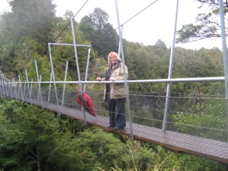
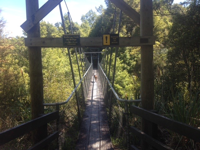 On right is the footbridge across the “Pillars of Hercules” where we understand another hydro power station was proposed but as they exceeded the original budget it never proceeded.
The following description was pinched off the Genesis website to explain the extent of the scheme and where the underground power station fits into the picture.
Without some local knowledge of the central plateau geography it is a difficult scheme to describe.

But first (and much more entertaining?) is our description of the local dilemma with the underground power station which was No 1 of our Christmas “wish-list” posts last December, which updated the May 2016 post, repeated below:
 Turangi’s Wish List…
The Caves of Mordor…?
This is the first – and probably the easiest target to achieve – in Turangi’s Wish List. Other similar tourist “wish list”challenges and solutions will follow. The simple aim of these is to indicate how to improve the economic status of Turangi, to unleash the potential available.
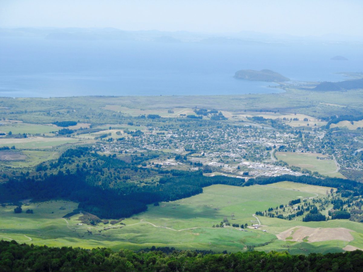
 Turangi is a quaint little tourist town perfectly located halfway to everywhere on SH1 on the the banks of the world famous trout fishing Tongariro River, surrounded by stunning national parks hiding several secrets. These are absolute gems in terms of potential tourist income which have been deliberately hidden for many years.
Tourism has never been more important – it is now NZ’s biggest export earner contributing $14.5 Billion or 20.7 % of NZ’s foreign exchange earnings for the year ended March. Those Wellington suits – aka economists – who have given up hope for the regions, should realise that NZ’s three biggest export earners are – in order of wealth production, are tourism, dairy and meat – all produced from the struggling futile provincial regions. Well I never…
 Turangi ticks all the boxes for tourism growth. So now is the time to expose Turangi’s secret tourism potential… which, ironically, Taupo have been reluctant to promote. Why? They are frightened of any local tourist attractions (ditto the rest of NZ) they cannot compete with.
The extract below is a repeat of another TRM Daily Report dated 31 May… It would provide a wonderful win-win solution for Genesis to win back the Turangi community’s goodwill for no cost. As it was mentioned again at a recent DGLT (Destination Great Lake Taupo) meeting it is still on the Christmas wish list in the minds of locals. 

Caves of Mordor
…… They (Genesis) might have been able to develop dams down the Waikato River without worrying about environmental damage or trout ladders etc. 40-50 years ago during the ‘Muldoon Think Big’ era, but in this new enlightened century their corporate policy is obsolete. They are now accountable.
 Previously Genesis earned public goodwill by donating to many worthwhile local community projects such as the Trout Centre, swimming pool complex, etc. Now Genesis have sold off half (49%) of their shares to the public, so many such subsidies have been reduced or eliminated.
In this new age of more sensitive enlightenment those extremes of corporate entities doing whatever they like to the environment, in the name of ‘progress’ (?) have gone. (A recent example was the Carp Farm fiasco in Taupo) Why?
 This is largely due to much improved public awareness and greatly improved communications via social media outlets exposing any abuses, such as the one you are reading and through investigative publications such as ‘Fishing & Outdoors’ newspapers. Wonderful stuff…
 To compensate the community with a viable solution, but which does not cost Genesis, (as we understand their motives for profit must come first) in Turangi we have the perfect solution. The conceptual basis for this to be of mutual benefit is so simple and obvious to everyone in Turangi, except Genesis.
So on behalf of so many locals and tourists we request Genesis to open up ‘our’ underground power station for public tourist viewing and all will be forgiven. OK? Everything is already there, it will not cost Genesis a cent, and Turangi will be forever grateful. We have been asking them now for many years to open it up, to no avail.
 Turangi has only one major industry – tourism – and needs to use every tourist opportunity locally, in the struggle for economic survival. For years we have continually heard of rumours to open up the Underground Power Station for tourists visits but it has never happened. That is apart from the odd one day a few years ago during the Turangi ‘Autumn Festival’ when it was always booked out. At TRM we continually receive tourist enquiries as well.
Genesis communication:
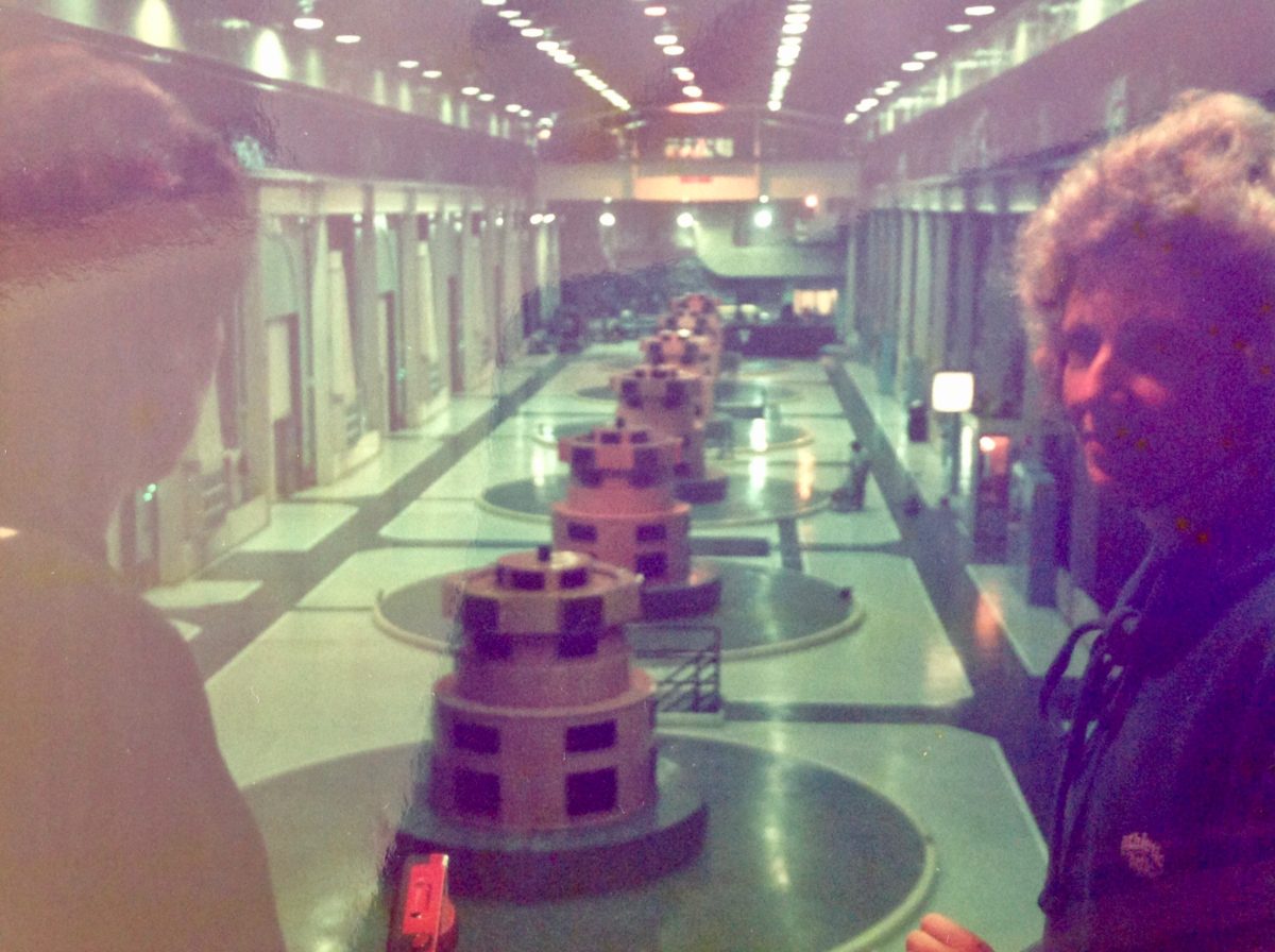
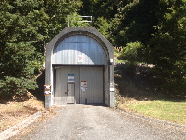
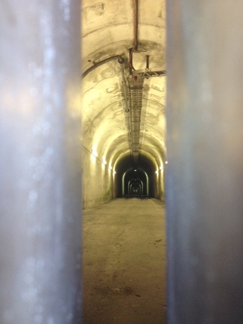
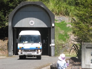
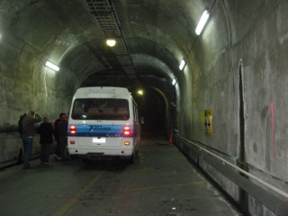
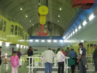
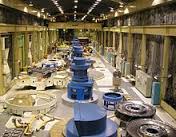
The photos by SWMBO are from one of their fe![]() w open days.
w open days.
In their last communication – when TRM emailed Genesis on 8 October 2015 – they replied as follows:
TRM Question: ‘Can you explain why Genesis have not allowed tourists trips to your underground power station? Turangi is desperate to develop more tourist opportunities. The Manapouri Power Station visit is one of the best attractions at Te Anau. So why not in Turangi?’
 Genesis Answer: “We are in the business of running and maintaining power schemes. Due to limited staff numbers and work commitments we are not set up in house to take public tours. I agree that NZ inc could do well by this type of activity. But we are simply not geared up for this at this point. We may choose to look at options available to us further down the track.”
Under-ground power station precedents:
A very successful underground power station tourism precedent is at Manapouri in the remotest southern location in the South Island.
The response from Manapouri (x Bruce Nicol, Assistant Operations Manager at Te Anau/Manapouri) confirmed Turangi’s lost $$$ tourist opportunity. i.e. In their summer season of six months in a much more remote location they get about 50,000 tourists each year paying net $20 per person for the power station visit = $1 Million p.a. (Turangi iSite could benefit with that income…) In addition they pay Meridian Energy $5 per head = $250,000 p.a. The full cost to tourists to include the boat trip across the lake is $79/head… Comparatively, conservatively, the Genesis Underground experience should attract over 100,000 visitors p.a. as it is open all year and has easy access from Turangi. Do your sums… $500,000 p.a….
West Island precedent:
There is another similar successful underground power station precedent in the Snowy Mountain scheme. Their hydro power scheme took 25 years to build and employed 100,000 to build nine power stations and provided irrigation via 16 dams. At Tumut No 2 they have underground tourist tours and audio visual displays.
Local Turangi-Tongariro (and Taupo) regional tourism is really neglecting a ‘unique’ opportunity. This is the only underground power station in the North Island. As seen in the photos, everything is ready to go, except Genesis… who remain in denial.
South Island Precedent:
Compare the very remote location of Manapouri (more detailed info below) to the Rangipo Power Station – just off SH1 about 25 km from Turangi, then factor in the additional nearby scenic opportunities including the Poutu Dam and the Pillars of Hercules on the upper Tongariro River…. So at Rangipo the potential would be even greater?
Turangi cannot accept their delays any longer. They continue to procrastinate and are too lazy – they just cannot be bothered… Yet we are advised by locals who worked on the original power scheme that the construction time was extended to provide for the road in to be sealed and a toilet installed to cater for tourists…
As long as Turangi is struggling to find more tourism opportunities, Genesis really have no legitimate excuse. It is still just (by 1%) a mainly public owned facility. Genesis have a social and moral responsibility now they have withdrawn their subsides for local community amenities. They still owe the region for the long term environmental damage to the Tongariro River that continues to detrimentally affect tourism.
Their ‘limited staff numbers’ excuse is nonsense. Other similar bus tours rely on the bus company and driver for everything. i.e. Manapouri drivers are required to gain an ‘Entry Certificate’ which is a Meridian Energy test for competency, security, safety, and emergency, and all drivers need current first aid certificates. Turangi shuttle bus drivers already have that. All tourists need is Genesis access approval and a swipe card.
SWMBO has offered to make it even more attractive for Genesis, indeed, completely irresistible.
In return for total exclusivity and to increase the payout to Genesis by 100% – (i.e. @ $10 per head x 100,000 visitors p.a. = $1 Million p.a.) and take total responsibility for all health and safety and guiding issues. If Genesis turn that down they will be the only company in NZ to walk away from $1 M p.a. for doing nothing. Their shareholders would be asking why?. Quite rightly so!
Genesis re-branding exercise:
Early warning – This exclusivity agreement with TRM will require an even more exciting tourist re-branding exercise for the few bored employees and contractors at the underground station, to appeal to the tourist sector. They will need to embrace the concept they are now in the tourist industry by discarding their corporate work overalls for more interesting dwarf and orc and hobbit costumes and renaming the underground station as the Giant Cave of Mordor. It is forecasted this proposal will attract more tourists than Hobbiton. For their part TRM will have to agree to change their Welcome to Turangi sign to “Welcome to the Cave of Mordor” sign.
Don’t laugh… SWMBO is always deadly serious when talking about money. Tourists will be visiting the Cave of Mordor for the next fifty years. Need proof? OK then. Compare a film called The Sound of Music (one of SWMBO’s favourites!) was made over 50 years ago but every year still attracts hundreds of thousands of tourists to visit Salzburg…
 The Lord of the Rings has already proven to generate similar tourist pulling power. If you doubt this then we challenge you to enjoy getting absolutely ripped off at Hobbiton @ $79 per head to admire a few round doors stuck in a hillside.
(Photo on right of wonderful Turangi MP, Louise Upston, inspecting Mordor from the safety of Pillars of Hercules bridge)
SWMBO’s brilliant Cave of Mordor concept will have more 100% pure sensational natural scenery to make it memorable and unique in the North Island. Well worth visiting at only $XX (Shuttle bus price is still confidential at this preliminary cost benefit feasibility planning stage).
If you would like to visit the Cave of Mordor then show your support – you will need to take this initiative a little further than just asking Genesis locally and being refused again.
Go over their heads by emailing this report to local Taupo MP Louise Upston (louise.upston@national.org.nz and cc to TRM) for her to take to the Genesis Board (chaired by x-PM 1997-1999, Rt Hon Dame Jennifer Shipley…) and forward copies to the Ministers of Tourism, whoever replaces John Key (ret’d?) and Paula Bennett.
That appears the only way we will influence the present local (heads in the sand) management. Please forward this report to them all. Thanking you all in anticipation… Don’t forget to wish them a Merry Christmas.
Manapouri Power Station
 Manapouri Power Station is an underground hydroelectric power station on the western arm of Lake Manapouri in Fiordland National Park, in the South Island of New Zealand.
At 850 MW installed capacity (although limited to 800 MW due to resource consent limits[3]), it is the largest hydroelectric power station in New Zealand, and the second largest power station in New Zealand.
 The station is noted for the controversy and environmental protests by the Save Manapouri Campaign against the raising the level of Lake Manapouri to increase the station’s head, which galvanised New Zealanders and were one of the foundations of the New Zealand environmental movement.
Completed in 1971, Manapouri was largely built to supply electricity to the Tiwai Point aluminium smelter near Bluff, some 160 km (99 mi) to the southeast, as well as into the South Island transmission network.
 The station utilises the 230-metre (750 ft) drop between the western arm of Lake Manapouri and the Deep Cove branch of the Doubtful Sound 10 km (6.2 mi) away to generate electricity.
The construction of the station required the excavation of almost 1.4 million tonnes of hard rock to build the machine hall and a 10 km tailrace tunnel, with a second parallel tailrace tunnel completed in 2002 to increase the station’s capacity.
 Since April 1999, the power station has been owned and operated by state-owned electricity generator Meridian Energy.
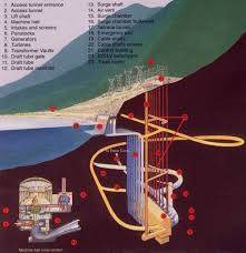
Genesis’ Tongariro Power Scheme description
The Tongariro Power Scheme can be divided into four key sections the Eastern Diversion, Western Diversion, Tongariro Section and Rotoaira Section.
Download a PDF map and cross section of the Tongariro Power Scheme
Eastern diversion

The Eastern Diversion extends from the Wahianoa Aqueduct on the southern flanks of Mt Ruapehu, eastward to the Moawhango Dam and north to the discharge point of the Moawhango Tunnel at the Rangipo Dam on the Tongariro River. The major structures in the Eastern Diversion and their purposes are outlined below.
Wahianoa Aqueduct
Takes water from tributaries of the Whangaehu River via 22 intakes and delivers it to Lake Moawhango. The Whangaehu River itself is not intercepted as it is naturally acidic, draining from the Crater Lake on Mt Ruapehu. The aqueduct is approximately 8,400m long and is buried underground. It transports water eastward under the Whangaehu River and into the Mangaio Tunnel.
Mangaio Tunnel and Drop Structure (1.8MW)

Water from the Wahianoa aqueduct passes under the Desert Road through the Mangaio Tunnel and either into Mangaio Power Station or a drop structure to enter the Lake Moawhango via the Mangaio Stream. Construction of the Mangaio Power Station began in January 2007 and commissioning began at the end of 2008. When operating, the power station will provide additional generation to the Tongariro Power Scheme of approximately 1.8MW’s of electricity.
Moawhango Dam

The Moawhango Dam dams the Moawhango River and Mangaio Stream to create Lake Moawhango. Lake Moawhango has a normal operating range of approximately 15.2 metres and as such rarely spills except during the largest floods.
Moawhango Tunnel

Water is taken from Lake Moawhango to the upper Tongariro River by a 19.2km tunnel. The tunnel flow is regulated by a discharge valve at the downstream end of the tunnel where it discharges into the Tongariro River, at Rangipo Dam.
Western diversion

The Western Diversion begins at the Whakapapa River where the water is routed north east via a 16.5km tunnel into Lake Te Whaiau. There are 4 smaller intakes into this tunnel which intercept water from the Tawhitikuri, Okupata, Taurewa, and Mangatepopo streams. Water is also diverted from the Whanganui River into the Te Whaiau Stream, which in turn discharges into Lake Te Whaiau. From Lake Te Whaiau water is discharged into Lake Otamangakau which is then discharged into Lake Rotoaira via the Wairehu Canal.
The Whakapapa Intake
The Whakapapa Intake comprises a concrete gravity dam set into the river bed just below the confluence of the Papamanuka Stream and the Whakapapa River. The intake has a flow capacity of 35 cubic metres per second. Any flow above this amount is passed over the spillway and down its natural course. A minimum flow of 3m3/s is maintained in the river downstream of the intake. Recreational flows are also released from the intake periodically.
Okupata, Taurewa, Mangatepopo and Tawhitikuri Intakes
Intake structures on each of these streams divert all the flow into the Whakapapa – Tawhitikuri – Whanganui Tunnel up to the following design capacities:
- Okupata 2 cubic metres per second
- Taurewa 2 cubic metres per second
- Mangatepopo 5 cubic metres per second
- Tawhitikuri 2 cubic metres per second
A minimum flow downstream of 0.5m3/s is released downstream of Mangatepopo Intake.
Whanganui Intake and Te Whaiau Culvert
The Whanganui Intake diverts water from the Whanganui River via a short tunnel into the Te Whaiau Stream, which then flows into Lake Te Whaiau. A minimum flow of 0.3 m3/s is maintained below this intake constantly.
The Te Whaiau Canal, Lake and Dam
Lake Te Whaiau Canal receives water from the Whakapapa – Tawhitikuri – Whanganui Tunnel and the Te Whaiau culvert. The dam spillway discharges into the old Te Whaiau stream bed.
The Otamangakau Canal, Lake and Dam
The Otamangakau Canal links Lake Te Whaiau to Lake Otamangakau. Lake Otamangakau provides short term storage for the western diversion flows.
The Wairehu Canal
The Wairehu Canal takes water from Lake Otamangakau to Lake Rotoaira. Here it combines with the inflows from the Eastern Diversion.
Tongariro

The Tongariro Section begins at the Waihohonu Intake and Tunnel, which transport water from the Waihohonu Stream to the Rangipo Dam on the Tongariro River. It then extends from the Rangipo Dam northward as far as the Poutu Intake, then North West to the Poutu Tunnel and Poutu Canal as far as the Poutu Dam. Waihohonu Intake and Tunnel takes water from the Waihohonu Stream via a 960 m long tunnel to the Rangipo head pond.

The Tongariro River creates a head pond for the Rangipo Power Station. Water is transported from here to the Rangipo Power Station via a headrace tunnel. A minimum flow of 0.6 m3/s is maintained below the dam to enhance the Blue Duck habitat. Recreational flows are also released from here periodically for sporting activities. For more information view our Rivers, Lakes and Rainfall section.
Rangipo Power Station (120MW underground)

The Rangipo Power Station is 63 m below the ground and was the second underground power station to be built in New Zealand. Rangipo was built underground to minimise the visual effect of the power station on the surrounding environment and the Tongariro River. Rangipo power station has two 60MW generators, and was commissioned in 1983.
Rangipo Tailrace Tunnel
The Rangipo Tailrace Tunnel discharges water from the Rangipo Power Station after electricity generation, through a 3 km tunnel to the Tongariro River, immediately upstream of the Poutu intake.

Rotoaira
The Rotoaira Section is the northern-most section of the scheme. It includes Lake Rotoaira, the Tokaanu Intake and Tunnel, Tokaanu Power Station and Tokaanu Tailrace.
Lake Rotoaira
Lake Rotoaira lies at an altitude of approximately 564m asl between Mt Tongariro and Mt Pihanga, south west of Lake Taupo. The lake is the reservoir for the Tokaanu Power Station.
Rotoaira Channel
Conveys water from the Poutu Dam to Lake Rotoaira.
Tokaanu Intake and Tunnel
Tokaanu intake is at the northern end of Lake Rotoaira. Here the water enters a 6.1 km Tunnel to Tokaanu Power Station.
Tokaanu Power Station (240MW)

The Tokaanu Power Station is a 240MW capacity station situated on the base of Mount Tihia at the southern end of Lake Taupo.
Tokaanu Tailrace
Water from the power station passes into the Tokaanu Tailrace channel, a 3.8km channel that discharges into Lake Taupo at Waihi Bay, west of the Tongariro Delta.
Tokaanu Stream Diversion

The Tokaanu stream diversion was created to preserve the Tokaanu stream (an important trout spawning stream) which crossed the path of the power station tailrace. The stream still crosses the path of the tailrace, but via an aqueduct under the tailrace road bridge.