The extent of this volcanic eruption 30 years ago is still not appreciated beyond the central plateau region.
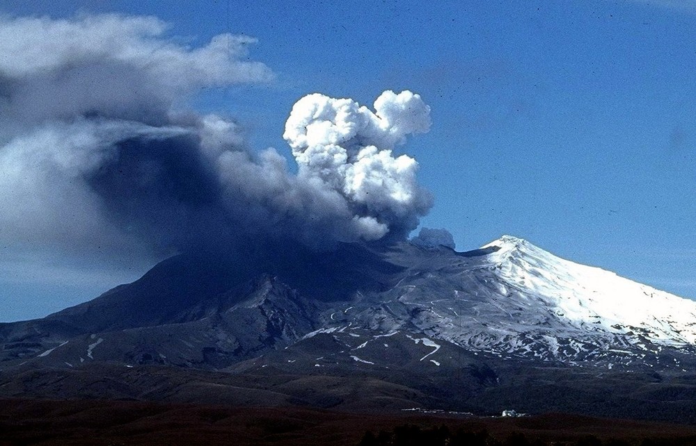
Ruapehu eruption, July 1996
This month marks 25 years since the start of the 1995-1996 Mt Ruapehu volcanic eruptions. The most notable was on September 23, 1995.

Remembering the Ruapehu eruptions
Sitting at 2797m, Mt Ruapehu is the highest mountain in the North Island and has been the source of eruptions for over 200,000 years, creating a significant impact on this country’s landscape, mythology and history.
Ruapehu means ‘pit of noise’ or ‘exploding pit’ in te reo Māori, a fitting description given that the mountain is one of the more active volcanoes in New Zealand.
The most notable of the mid-ninety’s eruptions was on September 23, 1995. With drama and enthusiasm, the volcano shot ballistics (flying rocks) into the sky and plumes of hot ash and steam. This eruption sent lahars – a raging mix of water, mud, ice and debris – surging through the ski fields and into the Whangaehu River. Fortunately, there were no injuries or deaths.
What people may not remember are the smaller eruptions earlier in that year, and even an eruption the week prior to September 23, also causing a lahar. Weather conditions at the time were poor, and visibility low, so the events didn’t get the same level of media and public interest as the eruption on September 23.
Later that year, and in 1996, further eruptions caused ashfall to settle on homes, cars, and buildings from later eruptions that year. Crops were damaged, and water supplies, roads and power were all disrupted. Some animals died as a result of ash ingestion and fish in local rivers were affected by lahars. The eruptions also forced flight cancellations, airport closures, and rerouted flights.
These eruptions removed the crater lake and modified the crater rim and outlet area. The new crater lake, which started to fill in 2003, filled to a level about nine metres above the outlet and was held in by a dam of volcanic debris. This dam failed in March 2007 creating a dam break lahar in the Whangaehu Valley and river.
A tragic history
In recent history, Mt Ruapehu’s crater lake outlet has collapsed every 50 years or so, sending a dam-break lahar down the mountain. The largest was in 1863, but the most devastating lahar was on Christmas Eve 1953. That lahar surged into the Whangaehu River weakening the Whangaehu River rail bridge, only minutes before the Wellington–Auckland night express train was due to cross.
The rail bridge buckled under the train, and the front carriages plunged into the flooded river, killing 151 of the 285 people on board.
To this day, the Tangiwai rail disaster remains one of New Zealand’s worst disasters.
Over the years, lessons from eruption impacts and dam breaks have led to improvements on the mountain and in the wider area. Bridges have been raised and built strong enough to withstand the force of a lahar. In anticipation of future lahar, monitoring equipment was installed to give advance warning to road, rail, and other infrastructure. A system to detect eruptions is also in place on the ski fields.
Keeping a watchful eye
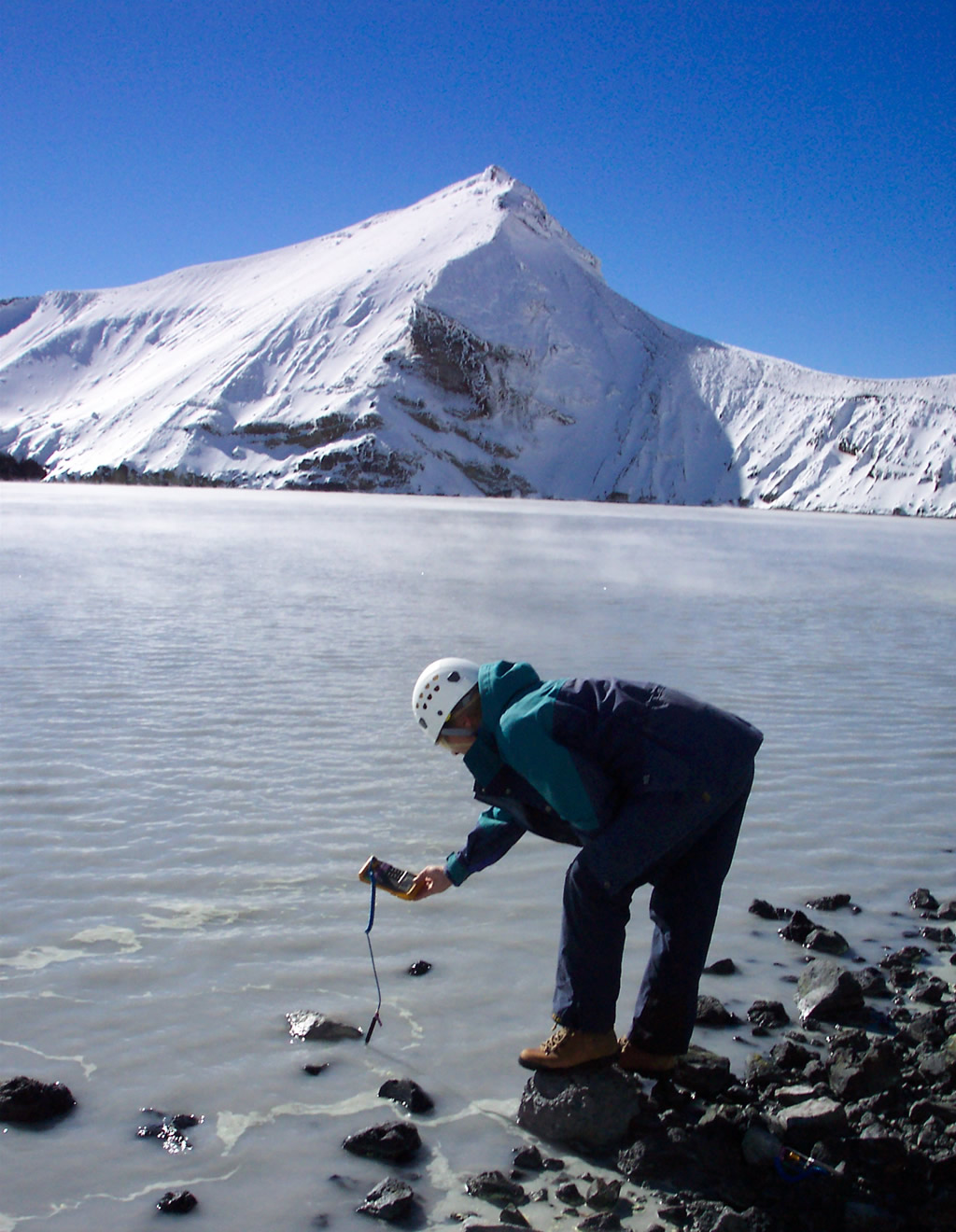
The power and volatility of this country’s active volcanoes has led to intense monitoring of our volcanoes over the years funded by EQC, through GeoNet. For Mt Ruapehu this monitoring is done in partnership with the Department of Conservation.
Monitoring Mt Ruapehu we have three web cameras, 10 seismographs and six microphones which detect volcanic explosions. In addition, nine continuous GPS stations around the volcano record ground deformation, and volcanologists sample water and gas from the crater lake (Te Wai ā-moe) and airborne gas monthly.
Mt Ruapehu eruption in 1995.
During the 1995–96 eruptions of Ruapehu, tephra was produced by the rise and explosive expansion of hot gas through molten andesite lava. This video clip shows gas explosions ripping apart the andesite and ejecting bombs and ash. Ash was spread by the wind over most parts of the central North Island.
Mary Argue

By Mary Argue of RNZ
Thirty years ago on Tuesday, Mt Ruapehu exploded in spectacular fashion, triggering headlines overseas and a somewhat haphazard emergency response at home.
Scientists who were there say it was good luck – not good management – that no one was killed.
The volcano in the central plateau had been rumbling away for months, when in September 1995 it blew – sending lahars thundering down valleys and plumes of smoke and volcanic ash kilometres into the sky.
It sparked the start of unrest that would last until mid-1996, with the eruptions costing the local economy millions in tourism dollars.
According to the Natural Hazards Commission (NHC), the acidic ash that spewed into the air caused havoc – blanketing areas up to 300km downwind and intermittently closing highways and airports, shorting power pylons and damaging the turbines at Rangipō power station.
Agriculture also took a hit, with ash damaging crops and killing about 2000 sheep grazing on ash-covered pastures. The NHC said it also led to a “small but notable increase in bronchitis”.
The most powerful eruption on September 23, sent a column of smoke and debris 12km high, and rocks 1.5km from the crater.

While skiers dropped their gear and fled, others went towards it, including NHC chief resilience and research officer Jo Horrocks, who was then a student volcanologist.
“The ash cloud was coming over the top of us and the whole sky just looked black, it was dark.
“It was difficult to breathe because the ash was just everywhere. You were just in a cloud of ash as it was raining down on you.”
When it became clear it was too dangerous on the Whakapapa ski field, Horrocks went to Tūroa, on the other side, where a now iconic looking photo of her was taken as the volcano rumbled beneath her.
“Little tremors and then big booming noises when the big explosions happened – really big – and [I was] just struck with the absolute power of nature.
“It was the single best day of my life.”

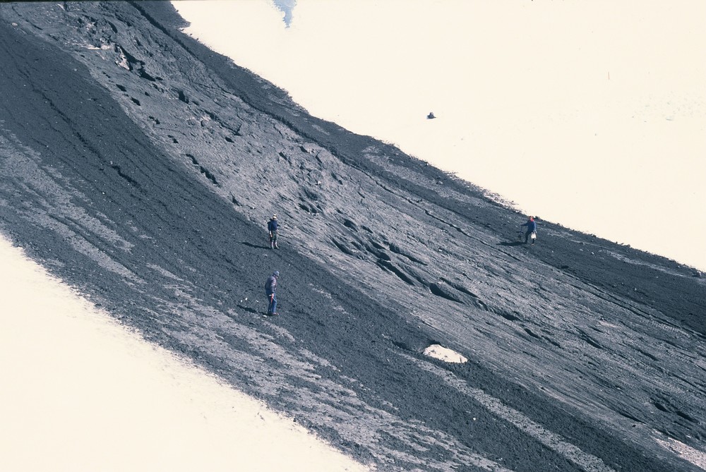
Earth Sciences volcanologist Brad Scott was also in the area that week, taking samples on the mountain in between eruptions – something he suspected health and safety would never allow these days.
But back then, organisations were scrambling, he said, as they reacted to the biggest volcanic activity – and ash plume – in 50 years.
“All of a sudden, people in agriculture, aviation, and transport and health and emergency management had to start thinking, ‘Oh god, how do I play this game?’
“There were no significant injuries, and certainly nobody was killed. There was probably a lot of luck at that time, rather than good management.”
Scott said research and monitoring had come a long way since, and scientists now believe a pulse of heat in the lake as far back as December 1994 was likely the first sign of an impending eruption.
“Back then if you had a map with dots on it representing where we’re collecting data and [compared it to] today’s map, the number of dots hasn’t changed significantly but what is represented by the dot has changed really dramatically.
“The types of equipment at the locations – that is significantly different.”
He said the rudimentary warning systems for lahars and managing the public had matured enormously, as well as scientists’ understanding of volcanic hazards, such as ballistics or volcanic cannon balls, which can be hurled kilometres in an eruption.
It wasn’t a coincidence, he said, that there was no infrastructure within 4km of a volcanic vent.
These days, Scott said monitoring of earthquakes, lake temperature, volcanic chemistry and gas emissions, all fed into volcanic alerts and bulletins that could trigger a range of responses from organisations such the Department of Conservation, police, transport and civil defence.
Horrocks said the emergency response in 1995-96, compared to what would happen today, was like “night and day”.
“With all due respect to responding agencies and scientists at the time, there was a lot of making it up as we went back then.”
She said the connections between the response, science, and infrastructure organisations – sparked by the unrest 30 years ago – were now well-established.
“I would very much hope … that we would be in fairly good stead if something happened in the future.”
A scenario that, according to Scott, is likely given Mt Ruapehu is an active volcano.
“Volcanoes are very good at putting their hand up, just how high they have their hand up, and how they’ve put it up is the challenge.”
– RNZ